File:Treaty Shore of Newfoundland.png

Size of this preview: 513 × 600 pixels. Other resolutions: 205 × 240 pixels | 410 × 480 pixels | 869 × 1,016 pixels.
Original file (869 × 1,016 pixels, file size: 420 KB, MIME type: image/png)
Captions
Captions
Add a one-line explanation of what this file represents
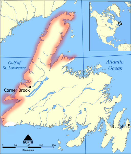
| Description | Map of Newfoundland, Canada, showing the Treaty Shore. |
| Date | (UTC) |
| Source | |
| Author |
|
| This is a retouched picture, which means that it has been digitally altered from its original version. Modifications: Added outline of the Treaty Shore, taken from an 1899 map of the shore held at the British Library. The original can be viewed here: Newfoundland map.png:
|
This file is licensed under the Creative Commons Attribution-Share Alike 3.0 Unported license.
- You are free:
- to share – to copy, distribute and transmit the work
- to remix – to adapt the work
- Under the following conditions:
- attribution – You must give appropriate credit, provide a link to the license, and indicate if changes were made. You may do so in any reasonable manner, but not in any way that suggests the licensor endorses you or your use.
- share alike – If you remix, transform, or build upon the material, you must distribute your contributions under the same or compatible license as the original.
Original upload log edit
This image is a derivative work of the following images:
- File:Newfoundland_map.png licensed with Cc-by-sa-3.0-migrated, GFDL
- 2008-01-14T21:49:41Z Qyd 869x1016 (323257 Bytes) {{Information |Description= |Source=cropped version of [[:Image:Newfoundland map blank.png]] |Date= Jan 2008 |Author= [[User:Coach.nyta|Coach.nyta]], edited by [[User:Qyd|Qyd]] |Permission=GNU |other_versions=[[:Image:Newfoun
Uploaded with derivativeFX
File history
Click on a date/time to view the file as it appeared at that time.
| Date/Time | Thumbnail | Dimensions | User | Comment | |
|---|---|---|---|---|---|
| current | 22:46, 8 November 2015 | | 869 × 1,016 (420 KB) | Flappiefh (talk | contribs) | Added Saint-Pierre and Miquelon. |
| 13:39, 6 February 2011 |  | 869 × 1,016 (377 KB) | Chase me ladies, I'm the Cavalry (talk | contribs) | {{Information |Description=Map of Newfoundland, Canada, showing the Treaty Shore. |Source=*File:Newfoundland_map.png |Date=2011-02-06 13:38 (UTC) |Author=*File:Newfoundland_map.png: Coach.nyta, edited by [[User:Qyd| |
You cannot overwrite this file.
File usage on Commons
There are no pages that use this file.
File usage on other wikis
The following other wikis use this file:
- Usage on id.wikipedia.org