File:Tree Map-Exportacoes do Amapa (2012).png

Size of this preview: 800 × 328 pixels. Other resolutions: 320 × 131 pixels | 640 × 263 pixels | 1,540 × 632 pixels.
Original file (1,540 × 632 pixels, file size: 39 KB, MIME type: image/png)
Captions
Captions
Add a one-line explanation of what this file represents
Summary edit
.png&action=edit§ion=1)
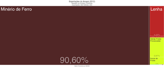
| Description | Exportações do Amapá em 2012 |
| Date | |
| Source | Plataforma DataViva |
| Author | DataViva |
| Permission (Reusing this file) |
Open Source |
Licensing edit
.png&action=edit§ion=2)

|
The copyright holder of this file allows anyone to use it for any purpose, provided that the copyright holder is properly attributed. Redistribution, derivative work, commercial use, and all other use is permitted. |
|
|
File history
Click on a date/time to view the file as it appeared at that time.
| Date/Time | Thumbnail | Dimensions | User | Comment | |
|---|---|---|---|---|---|
| current | 17:45, 14 January 2014 | 1,540 × 632 (39 KB) | Guilherme Sganserla (talk | contribs) | {{Information |Description =Exportações do Amapá em 2012 |Source =Plataforma DataViva |Author =DataViva |Date =13/01/2014 |Permission =Open Source |other_versions = }} |
You cannot overwrite this file.
File usage on Commons
There are no pages that use this file.
File usage on other wikis
The following other wikis use this file:
.png&oldid=474772454)