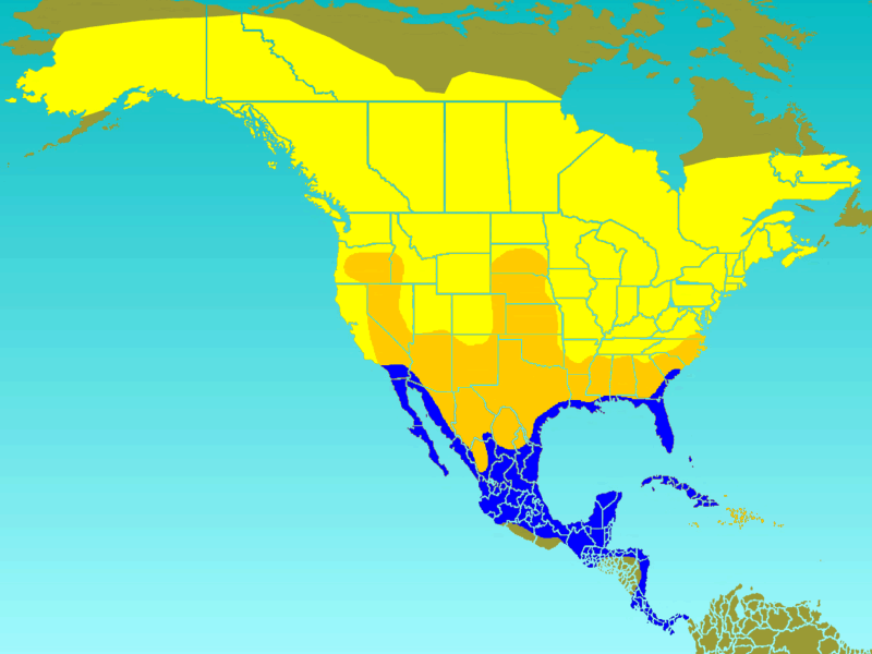
File:Tree Swallow-rangemap.gif
Tree_Swallow-rangemap.gif (800 × 600 pixels, file size: 55 KB, MIME type: image/gif)
File information
Structured data
Captions
Captions
Add a one-line explanation of what this file represents
| DescriptionTree Swallow-rangemap.gif |
Approximate range/distribution map of the Tree Swallow (Tachycineta bicolor). In keeping with WikiProject: Birds guidelines, the yellow area on the map indicates the summer-only range, the blue area indicates the winter-only range, green indicates the year-round range, and orange indicates areas on the map that the species will pass through during migratory periods. |
|||
| Date | ||||
| Source | [1] | |||
| Author | Ken Thomas | |||
| Permission (Reusing this file) |
This image is released to the public domain, and therefore no permission or credit is required.
|
File history
Click on a date/time to view the file as it appeared at that time.
| Date/Time | Thumbnail | Dimensions | User | Comment | |
|---|---|---|---|---|---|
| current | 13:02, 11 June 2008 |  | 800 × 600 (55 KB) | Ken Thomas (talk | contribs) | {{Information |Description=Approximate range/distribution map of the Tree Swallow (''Tachycineta bicolor''). <br>In keeping with WikiProject: Birds guidelines, the yellow area on the map indicates t |
You cannot overwrite this file.
File usage on Commons
The following 4 pages use this file:
File usage on other wikis
The following other wikis use this file:
- Usage on ar.wikipedia.org
- Usage on arz.wikipedia.org
- Usage on bg.wikipedia.org
- Usage on ca.wikipedia.org
- Usage on ceb.wikipedia.org
- Usage on cy.wikipedia.org
- Usage on en.wikipedia.org
- Usage on eo.wikipedia.org
- Usage on es.wikipedia.org
- Usage on eu.wikipedia.org
- Usage on fa.wikipedia.org
- Usage on fi.wikipedia.org
- Usage on fr.wikipedia.org
- Usage on he.wikipedia.org
- Usage on hu.wikipedia.org
- Usage on ml.wikipedia.org
- Usage on nl.wikipedia.org
- Usage on nv.wikipedia.org
- Usage on pl.wikipedia.org
- Usage on pt.wikipedia.org
- Usage on ro.wikipedia.org
- Usage on species.wikimedia.org
- Usage on sv.wikipedia.org
- Usage on uk.wikipedia.org
- Usage on www.wikidata.org
- Usage on zh.wikipedia.org
