File:Tres cañoñes - Suykutambo.jpg

Size of this preview: 800 × 178 pixels. Other resolutions: 320 × 71 pixels | 640 × 142 pixels | 2,802 × 622 pixels.
Original file (2,802 × 622 pixels, file size: 2.16 MB, MIME type: image/jpeg)
Captions
Captions
Add a one-line explanation of what this file represents
Summary
edit
| Description |
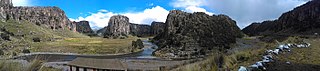
Español: Este majestuoso lugar conocido como Tres Cañones o Cañón de Suykutambo, por estar ubicado en el distrito que lleva el mismo nombre provincia de Espinar y departamento de Cusco, se compone de montañas en cuyas cimas se levantan monumentales formaciones rocosas de origen volcánico que dan el aspecto de interminables y misteriosos bosques de piedras.
Estos gigantes de piedra, los Tres Cañones, es el punto donde confluyen los ríos Apurímac, Callumani y Cerritambo para formar el Gran Apurímac.
Deutsch: Tres Cañones de Suykutambo; Einmündung des Río Cayomani (von links) und des Río Cerritambo (von rechts) in den Río Apurímac |
| Date | |
| Source | Own work |
| Author | Cali17quispe |
| Camera location | | View this and other nearby images on: OpenStreetMap |
|---|
YAURI- ESPINAR- CUSCO
Licensing
edit
I, the copyright holder of this work, hereby publish it under the following license:
This file is licensed under the Creative Commons Attribution-Share Alike 4.0 International license.
- You are free:
- to share – to copy, distribute and transmit the work
- to remix – to adapt the work
- Under the following conditions:
- attribution – You must give appropriate credit, provide a link to the license, and indicate if changes were made. You may do so in any reasonable manner, but not in any way that suggests the licensor endorses you or your use.
- share alike – If you remix, transform, or build upon the material, you must distribute your contributions under the same or compatible license as the original.

|
This image was uploaded as part of Wiki Loves Monuments 2017.
|
 |
File history
Click on a date/time to view the file as it appeared at that time.
| Date/Time | Thumbnail | Dimensions | User | Comment | |
|---|---|---|---|---|---|
| current | 21:00, 3 September 2017 | 2,802 × 622 (2.16 MB) | Cali17quispe (talk | contribs) | User created page with UploadWizard |
You cannot overwrite this file.
File usage on Commons
The following page uses this file:
File usage on other wikis
The following other wikis use this file:
- Usage on de.wikipedia.org
- Usage on es.wikipedia.org
- Usage on www.wikidata.org