File:Tri-State Tornado map.PNG
Size of this preview: 735 × 600 pixels. Other resolutions: 294 × 240 pixels | 589 × 480 pixels | 852 × 695 pixels.
Original file (852 × 695 pixels, file size: 61 KB, MIME type: image/png)
Captions
Captions
Add a one-line explanation of what this file represents
Summary edit
| Description |
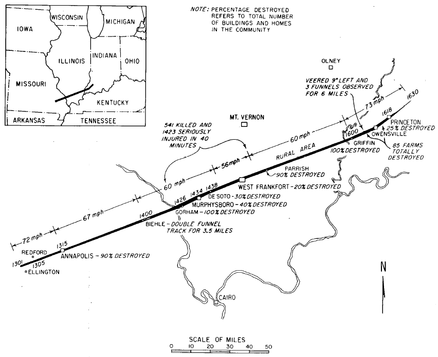
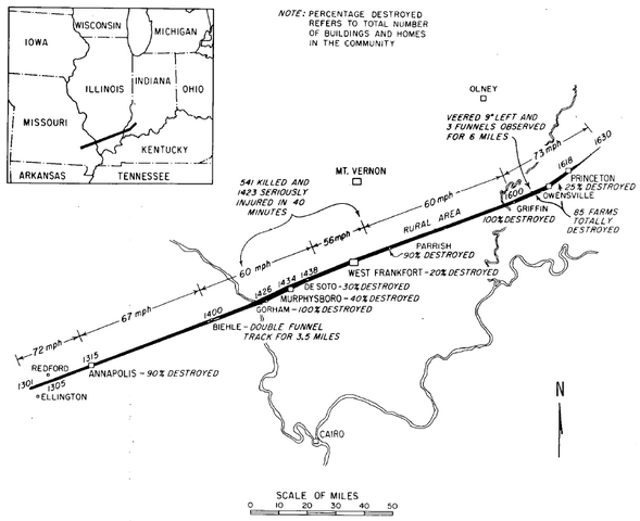
English: Original track map of the 219-mile, 3.5 hour Tri-State Tornado which killed 695 in Missouri, Illinois, and Indiana on 18 March 1925. |
| Date | |
| Source | Illinois Tornadoes. Circular 103. Illinois State Water Survey: Urbana-Champaign, IL. |
| Author | Wilson, John W., and Stanley A. Changnon, Jr. |
Licensing edit
This work is in the public domain in the United States because it is a work prepared by an officer or employee of the United States Government as part of that person’s official duties under the terms of Title 17, Chapter 1, Section 105 of the US Code.
Note: This only applies to original works of the Federal Government and not to the work of any individual U.S. state, territory, commonwealth, county, municipality, or any other subdivision. This template also does not apply to postage stamp designs published by the United States Postal Service since 1978. (See § 313.6(C)(1) of Compendium of U.S. Copyright Office Practices). It also does not apply to certain US coins; see The US Mint Terms of Use.
|
 | |
| This file has been identified as being free of known restrictions under copyright law, including all related and neighboring rights. | ||
File history
Click on a date/time to view the file as it appeared at that time.
| Date/Time | Thumbnail | Dimensions | User | Comment | |
|---|---|---|---|---|---|
| current | 03:14, 15 November 2006 | | 852 × 695 (61 KB) | Skyodyssey~commonswiki (talk | contribs) | Original track map of the 219-mile, 3.5 hour Tri-State Tornado which killed 695 in Missouri, Illinois, and Indiana on 18 March 1925. Wilson, John W., and Stanley A. Changnon, Jr. (1971). Illinois Tornadoes. Circular 103. Illinois State Water Survey: Urba |
You cannot overwrite this file.
File usage on Commons
The following page uses this file:
File usage on other wikis
The following other wikis use this file:
- Usage on fr.wikipedia.org