File:Tristan Map.png

Size of this preview: 685 × 600 pixels. Other resolutions: 274 × 240 pixels | 548 × 480 pixels | 877 × 768 pixels | 1,169 × 1,024 pixels | 2,338 × 2,048 pixels | 2,787 × 2,441 pixels.
Original file (2,787 × 2,441 pixels, file size: 639 KB, MIME type: image/png)
Captions
Captions
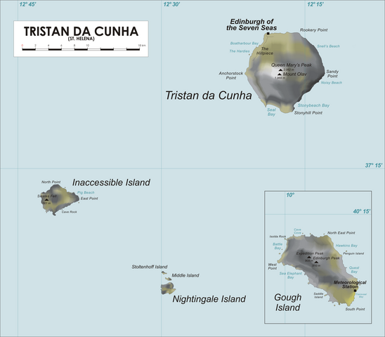
Map of Tristan da Cunha Group, Southern Atlantic Ocean
Summary edit
| Description |
Map of Tristan da Cunha Group, Southern Atlantic Ocean
|
| Date | 19 April 2006 (original upload date) |
| Source | No machine-readable source provided. Own work assumed (based on copyright claims). |
| Author | No machine-readable author provided. Varp~commonswiki assumed (based on copyright claims). |
| Other versions |
.png)
Licensing edit
| I, the copyright holder of this work, release this work into the public domain. This applies worldwide. In some countries this may not be legally possible; if so: I grant anyone the right to use this work for any purpose, without any conditions, unless such conditions are required by law. |
File history
Click on a date/time to view the file as it appeared at that time.
| Date/Time | Thumbnail | Dimensions | User | Comment | |
|---|---|---|---|---|---|
| current | 23:19, 9 April 2020 | | 2,787 × 2,441 (639 KB) | Getsnoopy (talk | contribs) | Fixed formatting for DMS grid lines labels as per SI. |
| 18:55, 23 March 2017 |  | 2,787 × 2,441 (578 KB) | Jeanjung212 (talk | contribs) | Lossless Compressed/optimized png decreasing file size by 237453 bytes | |
| 20:38, 5 April 2009 |  | 2,787 × 2,441 (810 KB) | Mahahahaneapneap (talk | contribs) | Compressed | |
| 11:43, 22 April 2006 |  | 2,787 × 2,441 (853 KB) | Varp~commonswiki (talk | contribs) | ||
| 18:28, 19 April 2006 |  | 2,542 × 2,441 (555 KB) | Varp~commonswiki (talk | contribs) | *Map of Tristan da Cunha Group, Southern Atlantic Ocean *drawn by varp |
You cannot overwrite this file.
File usage on Commons
The following 5 pages use this file:
File usage on other wikis
The following other wikis use this file:
- Usage on af.wikipedia.org
- Usage on ang.wikipedia.org
- Usage on an.wikipedia.org
- Usage on ar.wikipedia.org
- Usage on ast.wikipedia.org
- Usage on az.wikipedia.org
- Usage on bg.wikipedia.org
- Usage on bn.wikipedia.org
- Usage on br.wikipedia.org
- Usage on bs.wikipedia.org
- Usage on ca.wikipedia.org
- Usage on ceb.wikipedia.org
- Usage on cs.wikipedia.org
- Usage on cy.wikipedia.org
- Usage on da.wikipedia.org
- Usage on de.wikipedia.org
- Usage on de.wikivoyage.org
- Usage on el.wikipedia.org
- Usage on en.wikipedia.org
View more global usage of this file.