File:TroisRivieresLacSaintPierre1781.png

Size of this preview: 800 × 481 pixels. Other resolutions: 320 × 193 pixels | 640 × 385 pixels | 1,009 × 607 pixels.
Original file (1,009 × 607 pixels, file size: 801 KB, MIME type: image/png)
Captions
Captions
Add a one-line explanation of what this file represents
Summary edit
| Description |
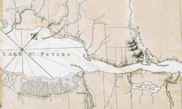
English: This is a detail from the source map, which is entitled: River of St. Lawrence, from Chaudiere to Lake St. Francis, &c. surveyed in pursuance... to Samuel Holland
This detail shows Lac St.-Pierre in the Saint Lawrence River, as well as the communities of Trois-Rivières, Nicolet, Pointe du Lac, and Rivière du Loup. |
| Date | |
| Source |
From the Library and Archive of Quebec (http://www.banq.qc.ca/). URL at time of upload: http://catalogue.banq.qc.ca/cgi-bin/bestn?id=%255FZjow%252F%25E2%257Dt%252DJQNFwwdX&act=8&auto=0&nov=1&v0=0&x=12&y=10&t0=Chaudiere+Holland&i0=0&s0=5&mdc=1&dac=1&v1=0&v2=0&v3=0&v4=0&md=200&sy=1775&ey=1790&scr=1 Call Number: G 3312 S5 1781 H6 CAR |
| Author | I.F.W Des Barres |
Licensing edit
|
This work is in the public domain in its country of origin and other countries and areas where the copyright term is the author's life plus 100 years or fewer. | |
| This file has been identified as being free of known restrictions under copyright law, including all related and neighboring rights. | |
File history
Click on a date/time to view the file as it appeared at that time.
| Date/Time | Thumbnail | Dimensions | User | Comment | |
|---|---|---|---|---|---|
| current | 23:25, 24 April 2009 | | 1,009 × 607 (801 KB) | Jeangagnon (talk | contribs) | correction de l'image |
| 21:54, 9 February 2009 |  | 1,009 × 607 (598 KB) | Magicpiano (talk | contribs) | {{Information |Description={{en|1=This is a detail from the source map, which is entitled: River of St. Lawrence, from Chaudiere to Lake St. Francis, &c. surveyed in pursuance... to Samuel Holland This detail shows Lac St.-Pierre in the Saint Lawrence Riv |
You cannot overwrite this file.
File usage on Commons
There are no pages that use this file.
File usage on other wikis
The following other wikis use this file:
- Usage on ar.wikipedia.org
- Usage on en.wikipedia.org
- Usage on fr.wikipedia.org
- Usage on it.wikipedia.org
- Usage on ja.wikipedia.org
- Usage on no.wikipedia.org
- Usage on zh.wikipedia.org