File:Tropical Storm Ernesto 2006-08-29 17-45.jpg

Size of this preview: 800 × 599 pixels. Other resolutions: 320 × 240 pixels | 640 × 479 pixels | 1,024 × 767 pixels | 1,282 × 960 pixels.
Original file (1,282 × 960 pixels, file size: 255 KB, MIME type: image/jpeg)
Captions
Captions
Add a one-line explanation of what this file represents
Summary edit
| Description |
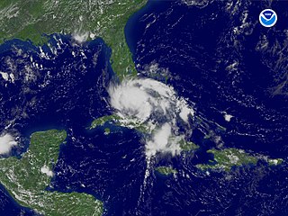
English: Tropical Storm Ernesto regional imagery, 2006.08.29 at 1745Z. Centerpoint Latitude: 23:38:18N Longitude: 79:56:25W. |
|||
| Date | ||||
| Source | http://www.nnvl.noaa.gov/cgi-bin/index.cgi?page=items&ser=111201&large=1 | |||
| Author | National Oceanic and Atmospheric Administration | |||
| Permission (Reusing this file) |
|
File history
Click on a date/time to view the file as it appeared at that time.
| Date/Time | Thumbnail | Dimensions | User | Comment | |
|---|---|---|---|---|---|
| current | 05:14, 30 August 2006 | | 1,282 × 960 (255 KB) | っ (talk | contribs) | {{Information| |Description = '''en''': Tropical Storm Ernesto regional imagery, 2006.08.29 at 1745Z.<br>Centerpoint Latitude: 23:38:18N Longitude: 79:56:25W. |Date = Aug. 29, 2006 |Source = http://www.nnvl.noaa.gov/members/images/111201.jpg <br>q. v. htt |
You cannot overwrite this file.
File usage on Commons
There are no pages that use this file.
File usage on other wikis
The following other wikis use this file:
- Usage on ja.wikinews.org