File:Tuareg area ru.png
Tuareg_area_ru.png (400 × 395 pixels, file size: 11 KB, MIME type: image/png)
Captions
Captions

|
This linguistic map image could be re-created using vector graphics as an SVG file. This has several advantages; see Commons:Media for cleanup for more information. If an SVG form of this image is available, please upload it and afterwards replace this template with
{{vector version available|new image name}}.
It is recommended to name the SVG file “Tuareg area ru.svg”—then the template Vector version available (or Vva) does not need the new image name parameter. |
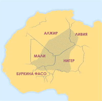
Areas where significant numbers of Tuaregs live. (Map with Russian labels.)
Sources used to draw this map edit
- Basset (1952)
- Bernus (1996) Touaregs: un peuple du désert.
- Lhote (1984)
- Sudlow (2001)
- Bougchiche, Lamara. (1997) Langues et litteratures berberes des origines a nos jours. Bibliographie internationale et sytematique. Paris: Ibis Press.
- Zavadovskij (1967)
- You are free:
- to share – to copy, distribute and transmit the work
- to remix – to adapt the work
- Under the following conditions:
- attribution – You must give appropriate credit, provide a link to the license, and indicate if changes were made. You may do so in any reasonable manner, but not in any way that suggests the licensor endorses you or your use.
This image was created by Mark Dingemanse and released under the Creative Commons Attribution 2.5 license. The image and any derivatives should be attributed to its creator (Mark Dingemanse) and/or to his agency (vormdicht); if you choose the latter, please provide a link to www.vormdicht.nl. Feel free to notify me when you're using one of my images outside of the Wikimedia projects; that way, I'll be able to let you know when I release an updated version.
File history
Click on a date/time to view the file as it appeared at that time.
| Date/Time | Thumbnail | Dimensions | User | Comment | |
|---|---|---|---|---|---|
| current | 11:10, 8 January 2008 | | 400 × 395 (11 KB) | Chesnok (talk | contribs) | Areas where significant numbers of Tuaregs live. (Map with Russian labels.) ==Sources used to draw this map== *Basset (1952) *Bernus (1996) ''Touaregs: un peuple du désert''. *Lhote (1984) *Sudlow (2001) *Bougchiche, Lamara. (1997) ''Langues et litterat |
You cannot overwrite this file.
File usage on Commons
There are no pages that use this file.
File usage on other wikis
The following other wikis use this file:
- Usage on ru.wikipedia.org
- Usage on ru.wikinews.org
- Usage on sr.wikinews.org
- Usage on uk.wikipedia.org