File:Tulsametroarea2.PNG
No higher resolution available.
Tulsametroarea2.PNG (558 × 297 pixels, file size: 12 KB, MIME type: image/png)
Captions
Captions
Add a one-line explanation of what this file represents

|
File:Tulsa Metro.svg is a vector version of this file. It should be used in place of this PNG file.
File:Tulsametroarea2.PNG → File:Tulsa Metro.svg
For more information, see Help:SVG. |
 |
| Description |
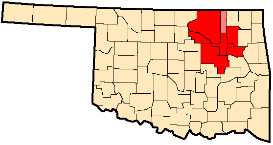
Map of the Tulsa Metropolitan Statistical Area−MSA (red), and the Bartlesville Micropolitan Statistical Area.
|
||
| Date | |||
| Source | http://en.wikipedia.org/wiki/File:Tulsametroarea2.PNG | ||
| Author | Okiefromokla | ||
| Permission (Reusing this file) |
|

Original upload log edit
The original description page is/was here. All following user names refer to en.wikipedia.
- 22:21, July 15, 2007 Okiefromokla (old) (169 bytes) (Tulsa MSA (red) and Tulsa-Bartlesville CSA (pink) [http://www.census.gov/population/www/estimates/metro_general/2006/List4.txt])
File history
Click on a date/time to view the file as it appeared at that time.
| Date/Time | Thumbnail | Dimensions | User | Comment | |
|---|---|---|---|---|---|
| current | 14:25, 30 June 2010 | | 558 × 297 (12 KB) | J`adore (talk | contribs) | {{Information |Description= MSA and CSA Tulsa |Source=http://en.wikipedia.org/wiki/File:Tulsametroarea2.PNG |Date=15 July 2007 |Author=Okiefromokla |Permission={{GFDL}} |other_versions= }} Category:Map |
You cannot overwrite this file.
File usage on Commons
There are no pages that use this file.