File:USACE Robert F Henry Lock and Dam.jpg

Size of this preview: 800 × 540 pixels. Other resolutions: 320 × 216 pixels | 640 × 432 pixels | 1,024 × 692 pixels | 1,500 × 1,013 pixels.
Original file (1,500 × 1,013 pixels, file size: 456 KB, MIME type: image/jpeg)
Captions
Captions
Add a one-line explanation of what this file represents
| Description |
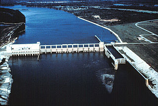
English: Aerial view of the Robert F. Henry Lock and Dam, formerly known as the Jones Bluff Lock and Dam, on the Alabama River. The dam spans the border between Autauga County and Lowndes County, Alabama, USA. The dam impounds R. E. “Bob” Woodruff Lake on the Alabama River. The lock and dam are located at river mile 245.4. The U.S. Army Corps of Engineers maintains the lock and dam for navigation on the Alabama River.
Coordinates: 32°19′25.04″N 86°46′59.04″W / 32.3236222°N 86.7830667°W |
|||
| Location | Autauga County and Lowndes County, Alabama, USA | |||
| Date | ||||
| Source |
U.S. Army Corps of Engineers Digital Visual Library Image page Image description page Digital Visual Library home page |
|||
| Author | Adrien Lamarre, U.S. Army Corps of Engineers | |||
| Permission (Reusing this file) |
|
File history
Click on a date/time to view the file as it appeared at that time.
| Date/Time | Thumbnail | Dimensions | User | Comment | |
|---|---|---|---|---|---|
| current | 21:40, 28 April 2007 | | 1,500 × 1,013 (456 KB) | DanMS (talk | contribs) | {{Information | Description = {{en|Aerial view of the Robert F. Henry Lock and Dam, formerly known as the Jones Bluff Lock and Dam, on the Alabama River. The dam spans the border between Autauga County and Lowndes County, Alabama, USA. The dam impounds |
You cannot overwrite this file.
File usage on Commons
There are no pages that use this file.
File usage on other wikis
The following other wikis use this file:
- Usage on ar.wikipedia.org
- Usage on de.wikipedia.org
- Usage on en.wikipedia.org
- Usage on fy.wikipedia.org
- Usage on it.wikipedia.org
- Usage on ja.wikipedia.org
- Usage on jv.wikipedia.org
- Usage on www.wikidata.org
- Usage on xmf.wikipedia.org