File:USGS 1045 Fig5.jpg

Size of this preview: 800 × 296 pixels. Other resolutions: 320 × 119 pixels | 640 × 237 pixels | 1,350 × 500 pixels.
Original file (1,350 × 500 pixels, file size: 174 KB, MIME type: image/jpeg)
Captions
Captions
Add a one-line explanation of what this file represents
Summary edit
| Description |
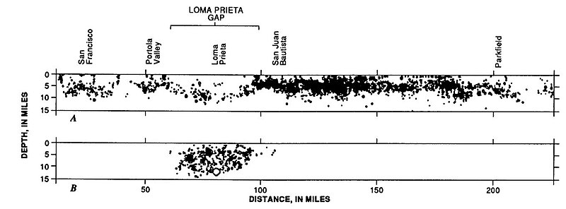
English: Seismicity along the San Andreas fault before and after the Loma Prieta earthquake |
||
| Date | |||
| Source | USGS Circular 1045, Figure 5 | ||
| Author | USGS | ||
| Other versions |
|


Licensing edit
This image is in the public domain in the United States because it only contains materials that originally came from the United States Geological Survey, an agency of the United States Department of the Interior. For more information, see the official USGS copyright policy.
|
File history
Click on a date/time to view the file as it appeared at that time.
| Date/Time | Thumbnail | Dimensions | User | Comment | |
|---|---|---|---|---|---|
| current | 12:13, 17 March 2009 | 1,350 × 500 (174 KB) | Mikenorton (talk | contribs) | {{Information |Description={{en|1=Seismicity along the San Andreas fault before and after the Loma Prieta earthquake}} |Source=USGU Circular 1045 |Author=USGS |Date=1989 |Permission= |other_versions= }} <!--{{ImageUpload|full}}--> |
You cannot overwrite this file.
File usage on Commons
There are no pages that use this file.
File usage on other wikis
The following other wikis use this file:
- Usage on en.wikipedia.org
- Usage on es.wikipedia.org
- Usage on he.wikipedia.org
- Usage on www.wikidata.org
- Usage on zh.wikipedia.org