File:US Navy 070819-N-0000X-001 Satellite imagery shows Hurricane Dean as it moves over Jamaica and heads toward the Yucatan Peninsula. The category 4 storm's winds are now sustained at 145 mph with higher gusts.jpg

Size of this preview: 682 × 599 pixels. Other resolutions: 273 × 240 pixels | 546 × 480 pixels | 874 × 768 pixels | 1,024 × 900 pixels.
Original file (1,024 × 900 pixels, file size: 659 KB, MIME type: image/jpeg)
Captions
Captions
Add a one-line explanation of what this file represents
Summary edit
| Description |
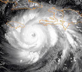
English: CARIBBEAN SEA (Aug. 19, 2007) – Satellite imagery shows Hurricane Dean as it moves over Jamaica and heads toward the Yucatan Peninsula. The category 4 storm's winds are now sustained at 145 mph with higher gusts. At 11:00 a.m. EDT, the center of Hurricane Dean was located near about 130 miles east-southeast of Kingston, Jamaica, and about 215 miles west-southwest of Port Au Prince, Haiti. The National Hurricane Center in Miami said the first hurricane of the Atlantic season is projected to reach the most dangerous hurricane classification, category 5, with winds of 160 mph before reaching the Mexican coastline near Cancun on Monday night or Tuesday. U.S. Navy photo (RELEASED) |
|||
| Date | ||||
| Source |
|
|||
| Author | U.S. Navy photo |

Licensing edit
This file is a work of a sailor or employee of the U.S. Navy, taken or made as part of that person's official duties. As a work of the U.S. federal government, it is in the public domain in the United States.
|
 | |
| This file has been identified as being free of known restrictions under copyright law, including all related and neighboring rights. | ||
File history
Click on a date/time to view the file as it appeared at that time.
| Date/Time | Thumbnail | Dimensions | User | Comment | |
|---|---|---|---|---|---|
| current | 17:45, 6 June 2010 | | 1,024 × 900 (659 KB) | Supportstorm (talk | contribs) | Cropped/ Removed Lines and Numbers/ Sharpened/ Contrast Correction |
| 08:49, 23 October 2009 |  | 1,024 × 1,024 (559 KB) | BotMultichillT (talk | contribs) | == {{int:filedesc}} == {{Information |description={{en|1=CARRIBEAN SEA (Aug. 19, 2007) – Satellite imagery shows Hurricane Dean as it moves over Jamaica and heads toward the Yucatan Peninsula. The category 4 storm's winds are now sustained at 145 mp |
You cannot overwrite this file.
File usage on Commons
There are no pages that use this file.
File usage on other wikis
The following other wikis use this file:
- Usage on en.wikipedia.org