File:UTC hue4map USA-IN.svg

Size of this PNG preview of this SVG file: 391 × 599 pixels. Other resolutions: 156 × 240 pixels | 313 × 480 pixels | 501 × 768 pixels | 668 × 1,024 pixels | 1,337 × 2,048 pixels | 2,887 × 4,423 pixels.
Original file (SVG file, nominally 2,887 × 4,423 pixels, file size: 61 KB)
Captions
Captions
Add a one-line explanation of what this file represents
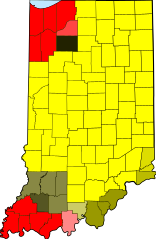
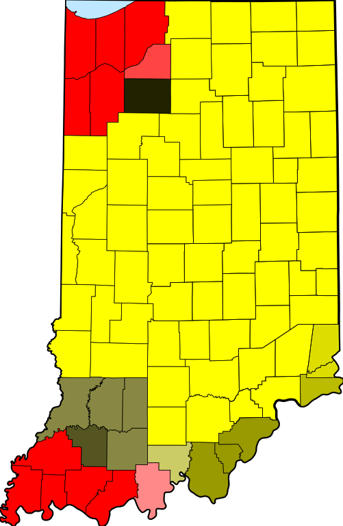
| Description | tz database zones for the US state of Indiana |
| Date | (UTC) |
| Source | |
| Author |
|
| This is a retouched picture, which means that it has been digitally altered from its original version. The original can be viewed here: Map of Indiana highlighting Adams County.svg:
|
I, the copyright holder of this work, hereby publish it under the following license:
| I, the copyright holder of this work, release this work into the public domain. This applies worldwide. In some countries this may not be legally possible; if so: I grant anyone the right to use this work for any purpose, without any conditions, unless such conditions are required by law. |
Original upload log edit
This image is a derivative work of the following images:
- File:Map_of_Indiana_highlighting_Adams_County.svg licensed with PD-self
- 2006-02-12T12:34:48Z David Benbennick 2887x4423 (56998 Bytes) {{subst:User:Dbenbenn/clm|county=Adams County|state=Indiana|type=county}}
Uploaded with derivativeFX
File history
Click on a date/time to view the file as it appeared at that time.
| Date/Time | Thumbnail | Dimensions | User | Comment | |
|---|---|---|---|---|---|
| current | 18:22, 14 December 2013 | | 2,887 × 4,423 (61 KB) | Rcsprinter123 (talk | contribs) | Lake Michigan blue |
| 13:41, 23 April 2013 |  | 2,887 × 4,423 (57 KB) | Nyttend (talk | contribs) | From the beginning, this map has shown the tz database's zones, making any division erroneous | |
| 01:40, 21 April 2013 |  | 2,887 × 4,423 (57 KB) | TimeZoneEditor (talk | contribs) | Reverted to version as of 03:49, 31 May 2012 | |
| 16:05, 16 August 2012 |  | 2,887 × 4,423 (57 KB) | Nyttend backup (talk | contribs) | From the beginning, this map has shown the tz database's zones, and the database doesn't make a distinction for the two sides of the 1961 line. | |
| 03:49, 31 May 2012 |  | 2,887 × 4,423 (57 KB) | TimeZoneEditor (talk | contribs) | Reverted to version as of 02:16, 31 May 2012, The IANA version is named "IANA" and located at File:UTC hue4map USA-IN IANA.svg | |
| 03:14, 31 May 2012 |  | 2,887 × 4,423 (57 KB) | Nyttend (talk | contribs) | No reason to upload a map of a different subject at this name; maps showing different things should be uploaded with different filenames | |
| 02:16, 31 May 2012 |  | 2,887 × 4,423 (57 KB) | TimeZoneEditor (talk | contribs) | This is not an IANA specific map. | |
| 06:11, 24 January 2012 |  | 2,887 × 4,423 (57 KB) | Nyttend (talk | contribs) | This map shows the tz database's zones, and the database doesn't make a distinction for the two sides of the 1961 line. | |
| 06:09, 24 January 2012 |  | 2,887 × 4,423 (58 KB) | MarcusBritish (talk | contribs) | Match yellows per request at Wiki Graphic Lab. | |
| 10:39, 9 October 2011 |  | 2,887 × 4,423 (57 KB) | TZ master (talk | contribs) | change colors to better show 1961 divide |
You cannot overwrite this file.
File usage on Commons
The following 4 pages use this file:
File usage on other wikis
The following other wikis use this file:
- Usage on bn.wikipedia.org
- Usage on ceb.wikipedia.org
- Usage on el.wikipedia.org
- Usage on en.wikipedia.org
- Usage on es.wikipedia.org
- Usage on fa.wikipedia.org
- Usage on fr.wikipedia.org
- Usage on id.wikipedia.org
- Usage on ilo.wikipedia.org
- Usage on ja.wikipedia.org
- Usage on sco.wikipedia.org
- Usage on ur.wikipedia.org
- Usage on zh.wikipedia.org