File:Union Landtage.svg

Size of this PNG preview of this SVG file: 443 × 599 pixels. Other resolutions: 177 × 240 pixels | 355 × 480 pixels | 567 × 768 pixels | 757 × 1,024 pixels | 1,513 × 2,048 pixels | 592 × 801 pixels.
Original file (SVG file, nominally 592 × 801 pixels, file size: 109 KB)
Captions
Captions
Add a one-line explanation of what this file represents
| Description |
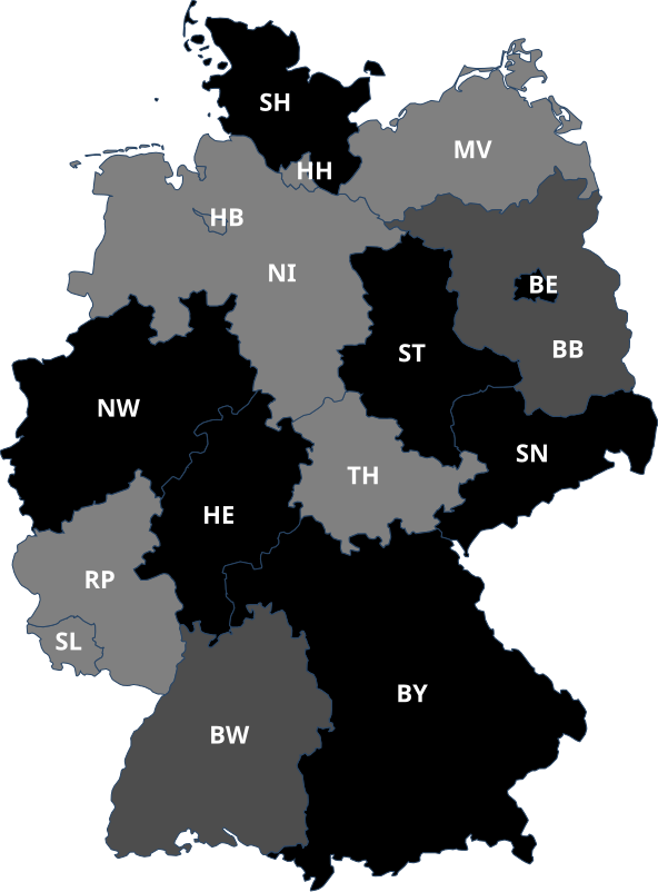
Länder, in denen die Union nicht im Landesparlament vertreten ist.
Länder, in denen die Union im Landesparlament als Oppositionspartei vertreten ist.
Länder, in denen die Union als kleiner Koalitionspartner an der Landesregierung beteiligt ist.
Länder, in denen die Union als großer Koalitionspartner an der Landesregierung beteiligt ist und den Regierungschef stellt. |
||
| Date | (UTC) | ||
| Source | Grüne Landtage.svg | ||
| Author |
|
||
| Other versions |
Derivative works of this file: CDU Landtage.svg
[]
|
||
| SVG development | This map was created with Adobe Illustrator.
|


I, the copyright holder of this work, hereby publish it under the following license:
This file is licensed under the Creative Commons Attribution-Share Alike 2.0 Germany license.
- You are free:
- to share – to copy, distribute and transmit the work
- to remix – to adapt the work
- Under the following conditions:
- attribution – You must give appropriate credit, provide a link to the license, and indicate if changes were made. You may do so in any reasonable manner, but not in any way that suggests the licensor endorses you or your use.
- share alike – If you remix, transform, or build upon the material, you must distribute your contributions under the same or compatible license as the original.

Original upload log edit
This image is a derivative work of the following images:
- File:Grüne_Landtage.svg licensed with Cc-by-sa-2.0-de
- 2011-02-21T09:12:27Z Firechris 592x801 (121007 Bytes) Nach Wahl in Hamburg 2011 (De facto nach Austritt aus der Hamburger Regierung am 28. November 2010)
- 2010-07-25T17:24:29Z Firechris 592x801 (121007 Bytes) (update: Regierungsbeteiligung NRW)
- 2009-11-06T21:55:03Z Voland77 592x801 (121007 Bytes) update: Regierungsbeteiligung Saarland
- 2009-09-27T17:16:45Z Voland77 592x801 (120990 Bytes) update
- 2009-08-31T11:49:13Z Voland77 592x801 (120974 Bytes) update +TH
- 2009-02-21T11:05:49Z Voland77 592x801 (120959 Bytes) + Regierungsbeteiligungen
- 2009-02-21T08:19:43Z Voland77 592x801 (120943 Bytes) {{Information |Description={{de|Karte der [[:de:Deutschland|Bundesrepublik Deutschland]] mit eingezeichneten Grenzen der [[:de:Bundesland|Bundesländer]].}} |Source=*[[:File:Karte_Bundesrepublik_Deutschland.svg|]] |Date=2009-
Uploaded with derivativeFX
File history
Click on a date/time to view the file as it appeared at that time.
| Date/Time | Thumbnail | Dimensions | User | Comment | |
|---|---|---|---|---|---|
| current | 14:48, 27 April 2023 | | 592 × 801 (109 KB) | Entbert (talk | contribs) | BE upd |
| 16:24, 8 November 2022 |  | 592 × 801 (109 KB) | Entbert (talk | contribs) | NI upd | |
| 15:00, 26 April 2022 |  | 592 × 801 (109 KB) | Entbert (talk | contribs) | SL upd | |
| 18:50, 21 November 2021 |  | 592 × 801 (109 KB) | Entbert (talk | contribs) | BB, MV upd | |
| 10:55, 17 November 2017 |  | 592 × 801 (109 KB) | NordNordWest (talk | contribs) | upd NI | |
| 09:00, 30 June 2017 |  | 592 × 801 (109 KB) | Martin Kraft (talk | contribs) | +Schleswig-Holstein +NRW SVG optimiert | |
| 22:33, 9 December 2016 |  | 592 × 801 (110 KB) | Chondrocladia (talk | contribs) | Berlin | |
| 12:49, 11 May 2016 |  | 592 × 801 (111 KB) | NordNordWest (talk | contribs) | upd BW | |
| 12:26, 5 December 2014 |  | 592 × 801 (111 KB) | NordNordWest (talk | contribs) | upd TH | |
| 12:08, 19 February 2013 |  | 592 × 801 (116 KB) | Kleiner Stampfi (talk | contribs) | nach Regierungsbildung in Niedersachsen am 19. Februar 2013 |
You cannot overwrite this file.
File usage on Commons
The following 21 pages use this file:
- User:Magog the Ogre/Political maps/2016 December 1-10
- User:Magog the Ogre/Political maps/2016 May 11-20
- User:Magog the Ogre/Political maps/2017 June 21-30
- User:Magog the Ogre/Political maps/2017 November 11-20
- User:Magog the Ogre/Political maps/2021 November 21-30
- User:Magog the Ogre/Political maps/2022 April 21-30
- User:Magog the Ogre/Political maps/2022 November 1-10
- User:Magog the Ogre/Political maps/2023 April 21-30
- File:AfD Landtage.svg
- File:CDU Landtage.svg
- File:CSU Landtage.svg
- File:FDP Landtage.svg
- File:FW Landtage.svg
- File:Grüne Landtage.svg
- File:Linke Landtage.svg
- File:NPD Landtage.svg
- File:Piratenpartei Landtage.svg
- File:SPD Landtage.svg
- File:SSW Landtage.svg
- File:Union Landtage.svg
- Template:Other versions/Landtage
File usage on other wikis
The following other wikis use this file:
- Usage on de.wikipedia.org
- Usage on es.wikipedia.org
- Usage on fr.wikipedia.org
- Usage on it.wikipedia.org