File:United Kingdom AV referendum area results.svg

Size of this PNG preview of this SVG file: 405 × 599 pixels. Other resolutions: 162 × 240 pixels | 324 × 480 pixels | 519 × 768 pixels | 692 × 1,024 pixels | 1,384 × 2,048 pixels | 871 × 1,289 pixels.
Original file (SVG file, nominally 871 × 1,289 pixels, file size: 4.45 MB)
Captions
Captions
Add a one-line explanation of what this file represents
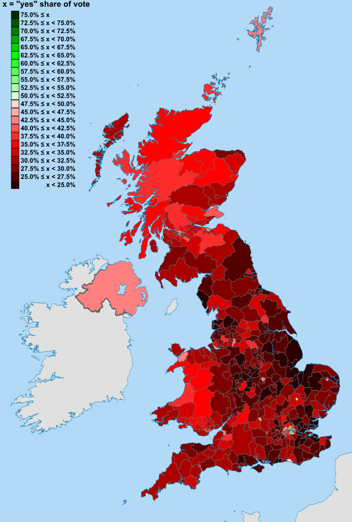
| Description | Map of the United Kingdom showing the voting areas for the Alternative Vote referendum, 2011. The voting areas are the 326 districts of England, 73 Scottish Parliament constituencies, 40 Welsh Assembly constituencies and Northern Ireland (a total of 440 areas). |
| Date | |
| Source |
National Geospatial-Intelligence Agency
|
| Author |
Nilfanion, created using Ordnance Survey data Jolly Janner for shading |
| Permission (Reusing this file) |
This file is licensed under the Creative Commons Attribution-Share Alike 3.0 Unported license.
|
File history
Click on a date/time to view the file as it appeared at that time.
| Date/Time | Thumbnail | Dimensions | User | Comment | |
|---|---|---|---|---|---|
| current | 22:03, 7 May 2011 | | 871 × 1,289 (4.45 MB) | Jolly Janner (talk | contribs) | Shaded all areas I think |
| 19:28, 7 May 2011 |  | 871 × 1,289 (4.44 MB) | Jolly Janner (talk | contribs) | Preview | |
| 16:40, 1 May 2011 |  | 871 × 1,289 (4.19 MB) | Nilfanion (talk | contribs) | {{Information |Description=Map of the United Kingdom showing the voting areas for the Alternative Vote referendum, 2011<!-- Replace with "showing the results ..." after results are available and map u |
You cannot overwrite this file.
File usage on Commons
The following 12 pages use this file:
- File:United Kingdom EU membership referendum 2016 map.svg
- File:United Kingdom EU referendum 2016 area results-de.svg
- File:United Kingdom EU referendum 2016 area results-en.svg
- File:United Kingdom EU referendum 2016 area results.svg
- File:United Kingdom EU referendum 2016 area results 2-tone.svg
- File:United Kingdom EU referendum 2016 area results 2.svg
- File:United Kingdom EU referendum 2016 area results BrB.svg
- File:United Kingdom EU referendum 2016 area results LYB.svg
- File:United Kingdom EU referendum 2016 area results OrB.svg
- File:Welsh devolution referendum, 1979.svg
- File:Welsh devolution referendum, 1997.svg
- File:Welsh devolution referendum, 2011.svg
File usage on other wikis
The following other wikis use this file:
- Usage on de.wikipedia.org
- Usage on en.wikipedia.org
- Usage on fa.wikipedia.org
- Usage on fr.wikipedia.org
- Usage on it.wikipedia.org
- Usage on ru.wikipedia.org