File:United Nations General Assembly Resolution 181 boundaries.jpg

Original file (2,828 × 8,208 pixels, file size: 18.87 MB, MIME type: image/jpeg)
Captions
Captions
Summary edit
| Description |
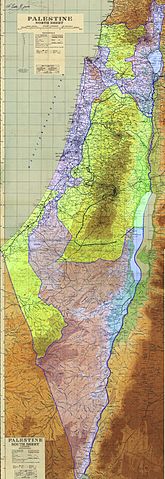
English: Boundaries recommended by UNGA Res 181 November 29, 1947 : Closely following the text of the resolution for both the Arab State and the Jewish State.[1]
Primary Sources used here: enabling editors to find suitable Secondary Sources .. & .. WP:RS accurately reflecting the actual wording of the cited documents, resolutions, statements etc., as required for articles in Wikipedia. Does not include the corpus separatum: Between the termination of the Mandate and the Armistices of 1949, only Israeli statehood had been established and; corpus separatum for Jerusalem has never been instituted. May 15 1948 the extent of Israel’s Sovereign territories were stated: as being those of UNGA Res 181 in the Israeli Government’s official plea for recognition to the President of the USA. May 15, 1948 Letter From the Agent of the Provisional Government of Israel to the President of the United States, “MY DEAR MR. PRESIDENT: I have the honor to notify you that the state of Israel has been proclaimed as an independent republic within frontiers approved by the General Assembly of the United Nations in its Resolution of November 29, 1947, and that a provisional government has been charged to assume the rights and duties of government for preserving law and order within the boundaries of Israel, for defending the state against external aggression, and for discharging the obligations of Israel to the other nations of the world in accordance with international law. The Act of Independence will become effective at one minute after six o’clock on the evening of 14 May 1948, Washington time.”[2]. The US immediately recognized Israel as such. The British also recognized Israel as such and considered non-declared territories under Israel’s military control by the time of British recognition, as occupied. "Hansard 27 April 1950 His Majesty’s Government have also decided to accord de jure recognition to the State of Israel, subject to explanations on two points corresponding to those described above in regard to the case of Jordan. These points are as follows. First, that His Majesty’s Government are unable to recognise the sovereignty of Israel over that part of Jerusalem which she occupies, though, pending a final determination of the status of the area, they recognise that Israel exercises de facto authority in it. Secondly, that His Majesty’s Government cannot regard the present boundaries between Israel, and Egypt, Jordan, Syria and the Lebanon as constituting the definitive frontiers of Israel, as these boundaries were laid down in the Armistice Agreements concluded severally between Israel and each of these States, and are subject to any modifications which may be agreed upon under the terms of those Agreements, or of any final settlements which may replace them."[3]. May 22 1948 the extent of Israel’s territories were clearly stated again: in the Israeli Government’s Reply to the UNSC May 22 1948, Palestine is acknowledged as outside the territories of the State of Israel. The reply of the Provisional Government of Israel UNSC S/766 to the questions addressed to the Jewish authorities in Palestine. "at present over the entire area of the Jewish State as defined in the Resolution of the General Assembly of the 29th November, 1947. In addition, the Provisional Government exercises control over the city of Jaffa; Northwestern Galilee, including Acre, Zib, Base, and the Jewish settlements up to the Lebanese frontier; a strip of territory alongside the road from Hilda to Jerusalem; almost all of new Jerusalem; and of the Jewish quarter within the walls of the Old City of Jerusalem. The above areas, outside the territory of the State of Israel, are under the control of the military authorities of the State of Israel, who are strictly adhering to international regulations in this regard. The Southern Negev is uninhabited desert over which no effective authority has ever existed." - "the Government of the State of Israel operates in parts of Palestine outside the territory of the State of Israel" — "outside the area of the State" — "beyond the frontiers of the State of Israel" [4]. Aug 31 1949 already recognized & accepted as a UN Member State: Israel made it’s first official claim to territories beyond the extent of its already recognized sovereignty and not belonging to any other State. [5] Israel’s claim was rebuffed, citing the 1949 Armistice Agreements [6]. Legend images: for use with this file - currently at 125 x 125 pixels   |
| Date | |
| Source |
Derivative work based on map of Palestine compiled, drawn and printed by the Survey of Palestine in 1944, with updates to roads in January, 1946. The original was created under the British Mandate Government in Palestine and published in August 1944, according to [7]. See also [8]. Modifications to the original based on the UNGA Resolution 181 text for the recommended boundaries of the proposed states[9](Page 6) & [10] by Talknic.
|
| Author | Survey of Palestine; Talknic |
![[10]](http://mideastweb.org/palestine_partition_map_1947s.jpg)
Licensing edit
| This file is made available under the Creative Commons CC0 1.0 Universal Public Domain Dedication. | |
| The person who associated a work with this deed has dedicated the work to the public domain by waiving all of their rights to the work worldwide under copyright law, including all related and neighboring rights, to the extent allowed by law. You can copy, modify, distribute and perform the work, even for commercial purposes, all without asking permission.
|
File history
Click on a date/time to view the file as it appeared at that time.
| Date/Time | Thumbnail | Dimensions | User | Comment | |
|---|---|---|---|---|---|
| current | 02:41, 30 January 2013 | 2,828 × 8,208 (18.87 MB) | Slick-o-bot (talk | contribs) | Bot: convert to a non-interlaced jpeg (see bug #17645) | |
| 17:11, 22 October 2011 | 2,828 × 8,208 (16.7 MB) | Talknic (talk | contribs) | Areas are coloured for easier reading of the image | ||
| 14:27, 22 October 2011 | 2,828 × 8,208 (6.01 MB) | Talknic (talk | contribs) |
You cannot overwrite this file.
File usage on Commons
There are no pages that use this file.
File usage on other wikis
The following other wikis use this file:
- Usage on en.wikipedia.org
- Usage on sh.wikipedia.org