File:United States 1789-03 to 1789-08 eastern.jpg

Size of this preview: 538 × 600 pixels. Other resolutions: 215 × 240 pixels | 431 × 480 pixels | 897 × 1,000 pixels.
Original file (897 × 1,000 pixels, file size: 159 KB, MIME type: image/jpeg)
Captions
Captions
Add a one-line explanation of what this file represents

|
This map image could be re-created using vector graphics as an SVG file. This has several advantages; see Commons:Media for cleanup for more information. If an SVG form of this image is available, please upload it and afterwards replace this template with
{{vector version available|new image name}}.
It is recommended to name the SVG file “United States 1789-03 to 1789-08 eastern.svg”—then the template Vector version available (or Vva) does not need the new image name parameter. |

| Description |
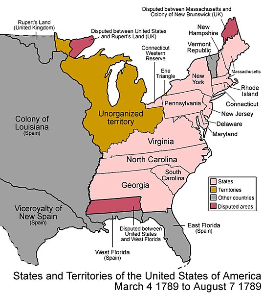
English: Map of the states and territories of the United States as it was from March 1789 to August 1789. |
| Date | |
| Source | sub area of File:United States 1789-03-1789-08.png plus my modifications (cropped to show eastern half, one label moved from cropped area to visible area) |
| Author | author of source image, plus my modifications (myself) |
| Permission (Reusing this file) |
same permission as original image (see below) |

|
Permission is granted to copy, distribute and/or modify this document under the terms of the GNU Free Documentation License, Version 1.2 or any later version published by the Free Software Foundation; with no Invariant Sections, no Front-Cover Texts, and no Back-Cover Texts. A copy of the license is included in the section entitled GNU Free Documentation License. |
| This file is licensed under the Creative Commons Attribution-Share Alike 3.0 Unported license. | ||
| ||
| This licensing tag was added to this file as part of the GFDL licensing update. |
This file is licensed under the Creative Commons Attribution 2.5 Generic license.
- You are free:
- to share – to copy, distribute and transmit the work
- to remix – to adapt the work
- Under the following conditions:
- attribution – You must give appropriate credit, provide a link to the license, and indicate if changes were made. You may do so in any reasonable manner, but not in any way that suggests the licensor endorses you or your use.
File history
Click on a date/time to view the file as it appeared at that time.
| Date/Time | Thumbnail | Dimensions | User | Comment | |
|---|---|---|---|---|---|
| current | 19:30, 31 July 2009 | | 897 × 1,000 (159 KB) | Notuncurious (talk | contribs) | {{Information |Description=Map of the states and territories of the United States as it was from March 1789 to August 1789. |Source=sub area of File:United States 1789-03-1789-08.png plus my modifications (cropped to show eastern half, one label move |
You cannot overwrite this file.
File usage on Commons
The following page uses this file:
- File:United.States.1789-03.to.1789-08 .eastern.jpg (file redirect)
File usage on other wikis
The following other wikis use this file:
- Usage on en.wikipedia.org
- Usage on kk.wikipedia.org
- Usage on vi.wikipedia.org