File:Universalis cosmographia secundum Ptholomaei traditionem et Americi Vespucii alioru(m)que lustrationes. LOC 2003626426.tif
Size of this JPG preview of this TIF file: 800 × 446 pixels. Other resolutions: 320 × 178 pixels | 640 × 357 pixels | 1,024 × 571 pixels | 1,280 × 713 pixels | 2,560 × 1,426 pixels | 18,000 × 10,029 pixels.
Original file (18,000 × 10,029 pixels, file size: 516.48 MB, MIME type: image/tiff)
Captions
Captions
Add a one-line explanation of what this file represents
Summary edit
| Warning | The original file is very high-resolution. It might not load properly or could cause your browser to freeze when opened at full size. |
|---|
| Description |
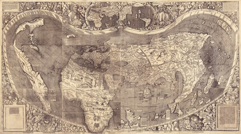
English: Relief shown pictorially. First document known to name America. Red ink grid on 2 sheets. Text applied over blank areas on 2 sheets. Manuscript annotations in the margin of 1 sheet. All sheets bear a watermark of a triple pointed crown. Two stamps on verso of upper left hand sheet: Fürstl. Waldburg Wolfegg'sches Kupferstichkabinett -- Furstl. Waldbg. Wolf. Bibliothek. Exhibited: Rivers, edens, empires: Lewis & Clark and the revealing of America, Library of Congress, Washington, D.C., July 24-Nov. 29, 2003. Available also through the Library of Congress Web site as a raster image. Includes text and ill. Printed surrogate in vault available for reference. LC digital image is a composite map from the twelve separate sheets. Originally bound with Waldseemüller's 1516 Carta marina in the Schöner Sammelband. |
|||||||||||||||||||||||
| Title | Universalis cosmographia secundum Ptholomaei traditionem et Americi Vespucii alioru[m]que lustrationes. | |||||||||||||||||||||||
| Shelf ID | G3200 1507 .W3 | |||||||||||||||||||||||
| Date | ||||||||||||||||||||||||
| Source | https://www.loc.gov/item/2003626426/ | |||||||||||||||||||||||
| Author |
|
|||||||||||||||||||||||
| Permission (Reusing this file) |
|
|||||||||||||||||||||||
| Other versions |
|
|||||||||||||||||||||||
| Location | Earth | |||||||||||||||||||||||
| Part of | American Memory · Catalog · Geography And Map Division · Discovery And Exploration | |||||||||||||||||||||||
| Subject | Early Maps · Earth · World Maps | |||||||||||||||||||||||


que_lustrationes._LOC_2003626426.jpg)
Licensing edit
|
This is a faithful photographic reproduction of a two-dimensional, public domain work of art. The work of art itself is in the public domain for the following reason:
The official position taken by the Wikimedia Foundation is that "faithful reproductions of two-dimensional public domain works of art are public domain".
This photographic reproduction is therefore also considered to be in the public domain in the United States. In other jurisdictions, re-use of this content may be restricted; see Reuse of PD-Art photographs for details. | ||||
File history
Click on a date/time to view the file as it appeared at that time.
| Date/Time | Thumbnail | Dimensions | User | Comment | |
|---|---|---|---|---|---|
| current | 08:25, 22 July 2018 |  | 18,000 × 10,029 (516.48 MB) | Fæ (talk | contribs) | LOC Maps https://www.loc.gov/item/2003626426/ #7882 |
You cannot overwrite this file.
File usage on Commons
The following page uses this file: