File:Unstable cliffs^ - geograph.org.uk - 1370525.jpg
No higher resolution available.
Unstable_cliffs^_-_geograph.org.uk_-_1370525.jpg (640 × 480 pixels, file size: 86 KB, MIME type: image/jpeg)
Captions
Captions
Add a one-line explanation of what this file represents
Summary edit
| Description |
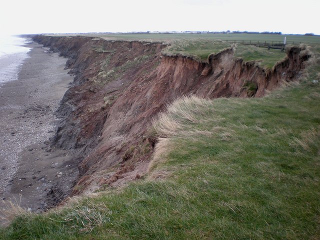
English: Unstable cliffs, Mappleton, East Riding of Yorkshire, England. This shows the coastline, with its boulder clay cliffs, looking south towards Aldbrough from the cliff-top car park at Mappleton. This area of the Holderness coast is subjected to continual landslip and erosion, as can be seen from the photo, with many buildings and property becoming inevitable casualties. |
| Date | |
| Source | From geograph.org.uk |
| Author | Dr Patty McAlpin |
| Permission (Reusing this file) |
Creative Commons Attribution Share-alike license 2.0 |
| Attribution (required by the license) | Dr Patty McAlpin / Unstable cliffs! / |
| Camera location | | View this and other nearby images on: OpenStreetMap |
|---|
_heading:135.00&language=en)
| Object location | | View this and other nearby images on: OpenStreetMap |
|---|
_heading:135.00&language=en)
Licensing edit

|
This image was taken from the Geograph project collection. See this photograph's page on the Geograph website for the photographer's contact details. The copyright on this image is owned by Dr Patty McAlpin and is licensed for reuse under the Creative Commons Attribution-ShareAlike 2.0 license.
|
This file is licensed under the Creative Commons Attribution-Share Alike 2.0 Generic license.
Attribution: Dr Patty McAlpin
- You are free:
- to share – to copy, distribute and transmit the work
- to remix – to adapt the work
- Under the following conditions:
- attribution – You must give appropriate credit, provide a link to the license, and indicate if changes were made. You may do so in any reasonable manner, but not in any way that suggests the licensor endorses you or your use.
- share alike – If you remix, transform, or build upon the material, you must distribute your contributions under the same or compatible license as the original.
File history
Click on a date/time to view the file as it appeared at that time.
| Date/Time | Thumbnail | Dimensions | User | Comment | |
|---|---|---|---|---|---|
| current | 16:37, 28 February 2011 | | 640 × 480 (86 KB) | GeographBot (talk | contribs) | == {{int:filedesc}} == {{Information |description={{en|1=Unstable cliffs! This shows the coastline, with its boulder clay cliffs, looking south towards Aldbrough from the cliff-top car park at Mappleton. This area of the Holderness coast is subjected to c |
You cannot overwrite this file.
File usage on Commons
There are no pages that use this file.