File:Up-subregions2 ml.svg

Size of this PNG preview of this SVG file: 572 × 599 pixels. Other resolutions: 229 × 240 pixels | 458 × 480 pixels | 733 × 768 pixels | 977 × 1,024 pixels | 1,954 × 2,048 pixels | 2,400 × 2,515 pixels.
Original file (SVG file, nominally 2,400 × 2,515 pixels, file size: 244 KB)
Captions
Captions
Utterpradesh subregions
Summary
edit| Description |
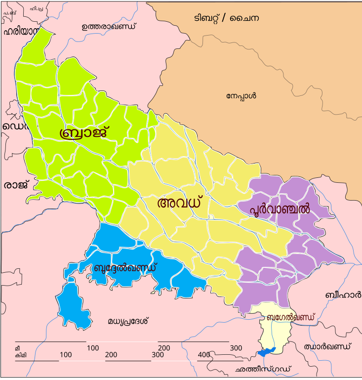
English: Map of UP subregions. It has been built on the public domain work "Uttar Pradesh locator map.svg" in Wikipedia. This work is also public domain. Free for any and all use without any restrictions whatsoever. |
| Date | |
| Source | Own work based on: Up-subregions2.svg |
| Author | Translated into malayalam by -Akbarali |
| Other versions |
[]
|
| SVG development | This locator map was created with Inkscape. This locator map is translated using SVG switch elements: all translations are stored in the same file. |


Licensing
edit
| This file is made available under the Creative Commons CC0 1.0 Universal Public Domain Dedication. | |
| The person who associated a work with this deed has dedicated the work to the public domain by waiving all of their rights to the work worldwide under copyright law, including all related and neighboring rights, to the extent allowed by law. You can copy, modify, distribute and perform the work, even for commercial purposes, all without asking permission.
|
File history
Click on a date/time to view the file as it appeared at that time.
| Date/Time | Thumbnail | Dimensions | User | Comment | |
|---|---|---|---|---|---|
| current | 18:13, 27 April 2019 | | 2,400 × 2,515 (244 KB) | Gnoeee (talk | contribs) | Spelling correction as per Malayalam SVG Corrections |
| 09:20, 27 February 2019 |  | 2,400 × 2,515 (244 KB) | Akbarali (talk | contribs) | User created page with UploadWizard |
You cannot overwrite this file.
File usage on Commons
The following 9 pages use this file: