File:Upr031808.gif
Upr031808.gif (350 × 316 pixels, file size: 23 KB, MIME type: image/gif)
File information
Structured data
Captions
Captions
Add a one-line explanation of what this file represents
Summary edit
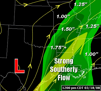
| DescriptionUpr031808.gif | The pattern at 12 pm CDT on 03/18/2008, with precipitable water values increasing markedly ahead of a storm system ("L") in Texas. Precipitable water, or water vapor contained in a vertical column of at atmosphere, is normally between .50" and .75" in mid-March. These values were more than doubled during this event. |
| Date | |
| Source | National Weather Service |
| Author | National Weather Service |
| Permission (Reusing this file) |
Public domain |
Licensing edit
| Public domainPublic domainfalsefalse |
This image is in the public domain because it contains materials that originally came from the U.S. National Oceanic and Atmospheric Administration, taken or made as part of an employee's official duties.
العربية ∙ čeština ∙ Deutsch ∙ Zazaki ∙ English ∙ español ∙ eesti ∙ suomi ∙ français ∙ hrvatski ∙ magyar ∙ italiano ∙ 日本語 ∙ 한국어 ∙ македонски ∙ മലയാളം ∙ Plattdüütsch ∙ Nederlands ∙ polski ∙ português ∙ română ∙ русский ∙ sicilianu ∙ slovenščina ∙ Türkçe ∙ Tiếng Việt ∙ 简体中文 ∙ 繁體中文 ∙ +/− |
 |
File history
Click on a date/time to view the file as it appeared at that time.
| Date/Time | Thumbnail | Dimensions | User | Comment | |
|---|---|---|---|---|---|
| current | 18:42, 13 April 2008 |  | 350 × 316 (23 KB) | Southern Illinois SKYWARN (talk | contribs) | {{Information |Description= The pattern at 12 pm CDT on 03/18/2008, with precipitable water values increasing markedly ahead of a storm system ("L") in Texas. Precipitable water, or water vapor contained in a vertical column of at atmosphere, is normally |
You cannot overwrite this file.
File usage on Commons
There are no pages that use this file.
