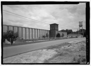
File:VIEW LOOKING NORTHEAST AT SOUTH OR MAIN ELEVATION OF THE FORMER SELMA COTTON MILL. THIS STRUCTURE IS NOW USED BY THE PHILLIES CIGAR COMPANY, AND HAS BEEN USED FOR CIGAR PRODUCTION SINCE HAER AL-184-1.tif

Size of this JPG preview of this TIF file: 800 × 576 pixels. Other resolutions: 320 × 231 pixels | 640 × 461 pixels | 1,024 × 738 pixels | 1,280 × 922 pixels | 2,560 × 1,844 pixels | 5,134 × 3,699 pixels.
Original file (5,134 × 3,699 pixels, file size: 18.11 MB, MIME type: image/tiff)
Captions
Captions
Add a one-line explanation of what this file represents
Summary edit
| Photographer |
Lowe, Jet, creator |
|||
| Title |
VIEW LOOKING NORTHEAST AT SOUTH OR MAIN ELEVATION OF THE FORMER SELMA COTTON MILL. THIS STRUCTURE IS NOW USED BY THE PHILLIES CIGAR COMPANY, AND HAS BEEN USED FOR CIGAR PRODUCTION SINCE THE 1940'S. THIS BUILDING IS THE BEST SURVIVING EXAMPLE OF A COTTON MILL BUILT USING THE CHARLES A.M. PRARAY BUILDING METHOD PATENTED IN 1894. SELMA COTTON MILL WAS BUILT IN TWO PHASES, c. 1898 AND c. 1900. MOST OF THE UNUSUAL TRIANGULAR BAYS STILL CONTAIN THE ORIGINAL WINDOWS, ALTHOUGH THEY HAVE BEEN PAINTED THE LOW, HIPPED ROOF BUILDING IN FRONT OF THE WATER TOWER IS USED AS AN OFFICE. - Selma Cotton Mill, 218 Morgan Avenue, Selma, Dallas County, AL |
|||
| Depicted place | Alabama; Dallas County; Selma | |||
| Date | 1998 | |||
| Dimensions | 5 x 7 in. | |||
| Current location |
Library of Congress Prints and Photographs Division Washington, D.C. 20540 USA http://hdl.loc.gov/loc.pnp/pp.print |
|||
| Accession number |
HAER AL-184-1 |
|||
| Credit line |
|
|||
| Source | https://www.loc.gov/pictures/item/al1286.photos.193170p | |||
| Permission (Reusing this file) |
|

| Camera location | | View this and other nearby images on: OpenStreetMap |
|---|
File history
Click on a date/time to view the file as it appeared at that time.
| Date/Time | Thumbnail | Dimensions | User | Comment | |
|---|---|---|---|---|---|
| current | 11:15, 1 July 2014 |  | 5,134 × 3,699 (18.11 MB) | Fæ (talk | contribs) | GWToolset: Creating mediafile for Fæ. HABS batch upload 29 June 2014 (101:150) |
You cannot overwrite this file.
File usage on Commons
The following page uses this file:
File usage on other wikis
The following other wikis use this file:
- Usage on en.wikipedia.org