File:VKF1 článek.gif

Size of this preview: 800 × 594 pixels. Other resolutions: 320 × 238 pixels | 640 × 475 pixels | 1,024 × 760 pixels | 1,280 × 950 pixels | 1,616 × 1,200 pixels.
Original file (1,616 × 1,200 pixels, file size: 67 KB, MIME type: image/gif)
Captions
Captions
Add a one-line explanation of what this file represents
Summary edit
| Description |
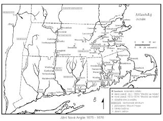
English: Map of Southern New England during King Philip´s War 1675-1676
Čeština: Mapa jižní Nové Anglie během války krále Filipa 1675-1676 |
| Date | |
| Source | Own work Mapa vytvořena pro diplomovou práci Vztahy Angličanů a Indiánů v Nové Anglii do roku 1676 (autor Miroslav Starý, FF UK 2000) a následně předělána pro článek Válka krále Filipa (autor Miroslav Starý, Historie a vojenství 2002) |
| Author | Whitesachem Miroslav Starý |
Licensing edit
| I, the copyright holder of this work, release this work into the public domain. This applies worldwide. In some countries this may not be legally possible; if so: I grant anyone the right to use this work for any purpose, without any conditions, unless such conditions are required by law. |
File history
Click on a date/time to view the file as it appeared at that time.
| Date/Time | Thumbnail | Dimensions | User | Comment | |
|---|---|---|---|---|---|
| current | 09:32, 11 February 2011 | | 1,616 × 1,200 (67 KB) | Whitesachem (talk | contribs) | {{Information |Description ={{en|1=Map of Souther New England during King Philip´s War 1675-1676}} {{cs|1=Mapa jižní Nové Anglie během války krále Filipa 1675-1676}} |Source ={{own}} Mapa vytvořena pro diplomovou práci Vztahy Angličan |
You cannot overwrite this file.
File usage on Commons
There are no pages that use this file.
File usage on other wikis
The following other wikis use this file:
- Usage on cs.wikipedia.org