File:Vahrentrap 1836.jpg

Size of this preview: 603 × 600 pixels. Other resolutions: 241 × 240 pixels | 483 × 480 pixels | 772 × 768 pixels | 1,029 × 1,024 pixels | 1,878 × 1,868 pixels.
Original file (1,878 × 1,868 pixels, file size: 2.36 MB, MIME type: image/jpeg)
Captions
Captions
Add a one-line explanation of what this file represents
Summary edit
| Description |
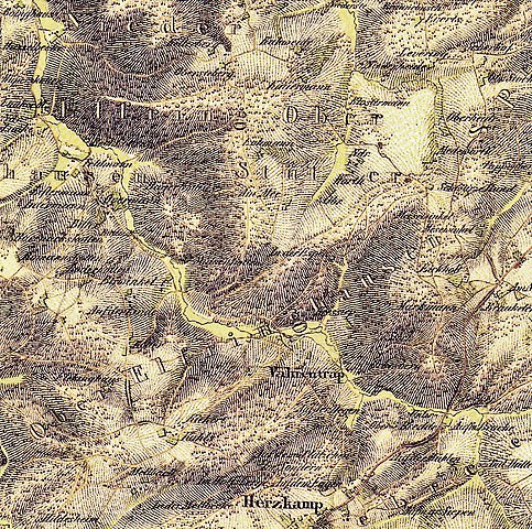
Deutsch: Kartenausschnitt aus dem Jahre 1836. Nieder- und Oberelfringhausen mit der Hofschaft Fahrentrappe (Vahrentrap) im Felderbachtal. Westlich liegende Höfe/Mühle (v.o.l.): Böhnkes (Boinghaus), Haselbeck, Laaker Mühle, Fellershof (Feldmann), Liftermann, Auerhof (Overmann), Bitter, Bärwinkel, Lindenhof (Auf der Linde), Flehinghaus, Kiekert, Kühls und Mellbeck. Südlich angrenzend liegt Gennebreck-Herzkamp. |
| Date | |
| Source | tim-online.nrw.de – Uraufnahme 1836-1850 |
| Author | NRW-Kartendienst, LAND NRW (2018) |
Licensing edit
|
This work is in the public domain in its country of origin and other countries and areas where the copyright term is the author's life plus 100 years or fewer. This work is in the public domain in the United States because it was published (or registered with the U.S. Copyright Office) before January 1, 1929. | |
| This file has been identified as being free of known restrictions under copyright law, including all related and neighboring rights. | |
File history
Click on a date/time to view the file as it appeared at that time.
| Date/Time | Thumbnail | Dimensions | User | Comment | |
|---|---|---|---|---|---|
| current | 11:36, 22 February 2019 | | 1,878 × 1,868 (2.36 MB) | Bärwinkel,Klaus (talk | contribs) | Etwas veränderte Version der Datei „Vahrentrap 1836.jpg“. Selbst bearbeitet am 22.02.2019 ~~~~ |
| 12:50, 21 November 2018 |  | 1,878 × 1,868 (2.37 MB) | Bärwinkel,Klaus (talk | contribs) | Vergrößerte Version der Datei. Selbst bearbeitet am 21.11.2018 ~~~~ | |
| 16:38, 19 November 2018 |  | 2,925 × 1,730 (3.36 MB) | Bärwinkel,Klaus (talk | contribs) | Etwas veränderte Version der Datei. Selbst bearbeitet am 19.11.2018 ~~~~ | |
| 14:22, 19 November 2018 |  | 2,925 × 1,730 (3.35 MB) | Bärwinkel,Klaus (talk | contribs) | {{Information |description ={{de|1=Kartenausschnitt aus dem Jahre 1836. Ober-Elfringhausen mit der Hofschaft Vahrentrap (Fahrentrappe). Umliegende Höfe (v.o.l.) Bitter, Bärwinkel, Lindenhof (Auf der Linde), Flehinghaus, Kiekert, Kühls und Mellbeck.}} |date =1836 |source =tim-online.nrw.de – Uraufnahme 1836-1850 |author =NRW-Kartendienst, LAND NRW (2018) }} Category:Elfringhausen |
You cannot overwrite this file.
File usage on Commons
The following page uses this file: