File:Vallée ubayette.jpg

Size of this preview: 687 × 599 pixels. Other resolutions: 275 × 240 pixels | 550 × 480 pixels | 881 × 768 pixels | 1,174 × 1,024 pixels | 2,348 × 2,048 pixels | 3,404 × 2,969 pixels.
Original file (3,404 × 2,969 pixels, file size: 6.84 MB, MIME type: image/jpeg)
Captions
Captions
Add a one-line explanation of what this file represents
Summary edit
| Description |
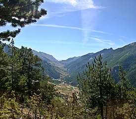
English: The Ubayette valley, as seen fron the serre de la platte ridge. On the background, the Larche mountain pass on the french-italian border is visible. The Ubayette springs lie in the Lauzanier valley. The entering of the Lauzanier valley is visible on the right bellow the pass. Another visible feature is the opposition between the sunny side (locally called Adret, here on the left), and the shadowed side (locally called Ubac, on the right of the picture). The sunny side was historically deforested and cultivated, and stil is partially cultivated today. It also habors all the villages and hamlets existing in the valley, plus the road. The shadowed side is covered by a forest of larches. Alpes-de-Haute-Provence département, France.
Français : La vallée de l'Ubayette, vue depuis le serre de la platte. Au fond, on distingue le col frontalier de Larche. L'Ubayette prend sa source dans le vallon du Lausanier, dont on devine l'entrée à droite sous le col. l'asymétrie entre l'adret (ici à gauche) et l'ubac (ici à droite) est très visible sur cette photo. L'adret a été déboisé et est encore partiellement cultivé. Les villages se développent sur ce versant qu'emprunte aussi la route. L'ubac est entièrement recouvert de mélèzes. Alpes-de-Haute-Provence, France. |
| Source | Own work |
| Author | Berrucomons |
| Camera location | | View this and other nearby images on: OpenStreetMap |
|---|
Licensing edit
I, the copyright holder of this work, hereby publish it under the following licenses:

|
Permission is granted to copy, distribute and/or modify this document under the terms of the GNU Free Documentation License, Version 1.2 or any later version published by the Free Software Foundation; with no Invariant Sections, no Front-Cover Texts, and no Back-Cover Texts. A copy of the license is included in the section entitled GNU Free Documentation License. |
This file is licensed under the Creative Commons Attribution-Share Alike 3.0 Unported, 2.5 Generic, 2.0 Generic and 1.0 Generic license.
- You are free:
- to share – to copy, distribute and transmit the work
- to remix – to adapt the work
- Under the following conditions:
- attribution – You must give appropriate credit, provide a link to the license, and indicate if changes were made. You may do so in any reasonable manner, but not in any way that suggests the licensor endorses you or your use.
- share alike – If you remix, transform, or build upon the material, you must distribute your contributions under the same or compatible license as the original.
You may select the license of your choice.
This image has been assessed using the Quality image guidelines and is considered a Quality image.
|
File history
Click on a date/time to view the file as it appeared at that time.
| Date/Time | Thumbnail | Dimensions | User | Comment | |
|---|---|---|---|---|---|
| current | 19:46, 7 November 2009 | | 3,404 × 2,969 (6.84 MB) | Berrucomons (talk | contribs) | {{Information |Description={{en|1=The Ubayette valley, as seen fron the ''serre de la platte'' ridge. On the background, the Larche mountain pass on the french-italian border is visible. The Ubayette springs lie in the Lauzanier valley. The entering of th |
You cannot overwrite this file.
File usage on Commons
The following 4 pages use this file:
File usage on other wikis
The following other wikis use this file:
- Usage on fr.wikipedia.org