File:Valladolid-loc.svg

Size of this PNG preview of this SVG file: 512 × 535 pixels. Other resolutions: 230 × 240 pixels | 459 × 480 pixels | 735 × 768 pixels | 980 × 1,024 pixels | 1,960 × 2,048 pixels.
Original file (SVG file, nominally 512 × 535 pixels, file size: 500 KB)
Captions
Captions
Add a one-line explanation of what this file represents
Summary edit
| Description |
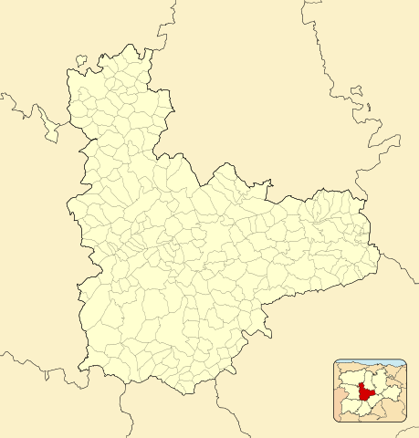
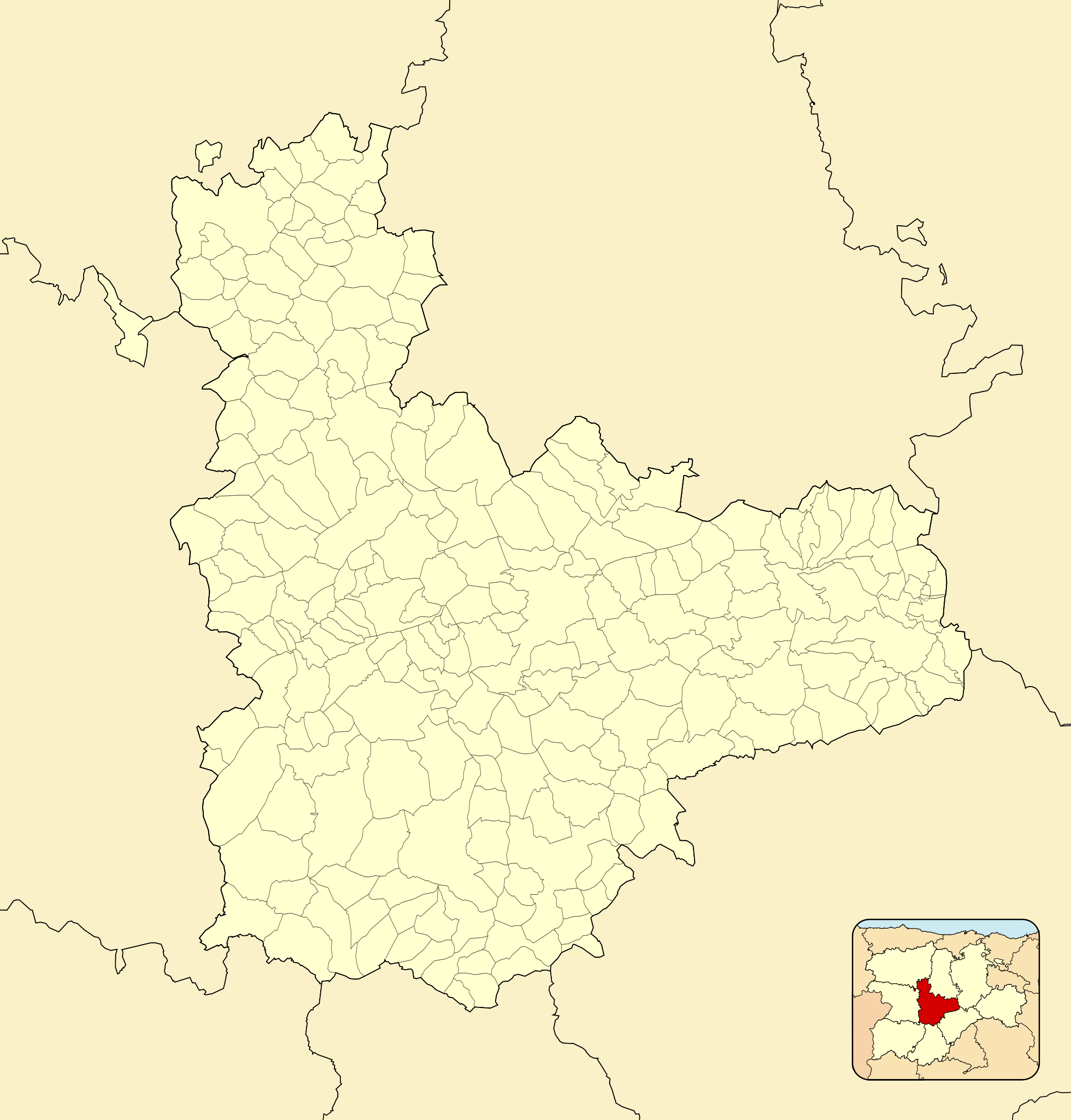
English: Location map of Province of Valladolid
Equirectangular projection, N/S stretching 130 %. Geographic limits of the map:
Español: Mapa de localización de la Provincia de Valladolid
Proyección equirrectangular, N/S estirada 130 %. Límites geográficos del mapa:
|
|
| Date | ||
| Source | Own work based on: EspañaLoc.svg | |
| Author | Miguillen | |
| SVG development |
|
Licensing edit
Miguillen, the copyright holder of this work, hereby publishes it under the following license:
This file is licensed under the Creative Commons Attribution-Share Alike 3.0 Unported license.
Attribution: Miguillen
- You are free:
- to share – to copy, distribute and transmit the work
- to remix – to adapt the work
- Under the following conditions:
- attribution – You must give appropriate credit, provide a link to the license, and indicate if changes were made. You may do so in any reasonable manner, but not in any way that suggests the licensor endorses you or your use.
- share alike – If you remix, transform, or build upon the material, you must distribute your contributions under the same or compatible license as the original.
File history
Click on a date/time to view the file as it appeared at that time.
| Date/Time | Thumbnail | Dimensions | User | Comment | |
|---|---|---|---|---|---|
| current | 11:07, 9 December 2010 | | 512 × 535 (500 KB) | Miguillen (talk | contribs) | id |
| 11:04, 9 December 2010 |  | 512 × 535 (499 KB) | Miguillen (talk | contribs) | colores | |
| 20:00, 10 May 2010 |  | 512 × 535 (251 KB) | Miguillen (talk | contribs) | == {{int:filedesc}} == {{Information |Description={{en|Location map of Province of Valladolid}} Equirectangular projection, N/S stretching 130 %. Geographic limits of the map: * N: 41.221046° N * S: 39.804255° N * W: 4 |
You cannot overwrite this file.
File usage on Commons
The following page uses this file:
File usage on other wikis
The following other wikis use this file:
- Usage on ba.wikipedia.org
- Usage on cs.wikipedia.org
- Usage on de.wikipedia.org
- Usage on eo.wikipedia.org
- Medina del Campo
- Kampaspero
- Simanko
- Ĝenerala Arkivo de Simanko
- Provinco Valadolido
- Municipoj de la provinco Valadolido
- Aguilar de Campos
- Barcial de la Loma
- Becilla de Valderaduey
- Berrueces
- Bolaños de Campos
- Bustillo de Chaves
- Cabezón de Valderaduey
- Ŝablono:Situo sur mapo Hispanio Provinco Valadolido
- Cabreros del Monte
- Castrobol
- Castroponce
- Ceinos de Campos
- Cuenca de Campos
- Fontihoyuelo
- Gatón de Campos
- Herrín de Campos
- La Unión de Campos
- Mayorga
- Medina de Rioseco
- Melgar de Abajo
- Melgar de Arriba
- Monasterio de Vega
- Montealegre de Campos
- Moral de la Reina
- Morales de Campos
- Palazuelo de Vedija
- Pozuelo de la Orden
- Quintanilla del Molar
- Roales de Campos
- Saelices de Mayorga
- San Pedro de Latarce
- Santa Eufemia del Arroyo
- Santervás de Campos
- Tamariz de Campos
- Tordehumos
- Urones de Castroponce
- Valdunquillo
- Valverde de Campos
- Vega de Ruiponce
View more global usage of this file.