File:Veel Forten en Werken liggen er op Het Eiland van Schalkwijk.jpg

Size of this preview: 795 × 600 pixels. Other resolutions: 318 × 240 pixels | 636 × 480 pixels | 1,018 × 768 pixels | 1,280 × 966 pixels | 2,560 × 1,931 pixels | 3,360 × 2,535 pixels.
Original file (3,360 × 2,535 pixels, file size: 8.59 MB, MIME type: image/jpeg)
Captions
Captions
Add a one-line explanation of what this file represents
Summary edit
| Description |
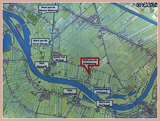
Nederlands: Veel van de forten op het Eiland zijn nu toegankelijk gemaakt, alleen voor Fort Honswijk moeten we nog even geduld hebben. Maar er wordt aan gewerkt, het fort is door de gemeente houten "gekocht".en zal worden opengesteld. Inmiddels is Fort Honswijk ook in 2018 door de gemeente Houten opengesteld. het nieuwe Klompenpad gaat over het fort. |
| Date | |
| Source | Own work |
| Author | Jan dijkstra |
| Camera location | | View this and other nearby images on: OpenStreetMap |
|---|
Licensing edit
I, the copyright holder of this work, hereby publish it under the following license:
This file is licensed under the Creative Commons Attribution-Share Alike 4.0 International license.
- You are free:
- to share – to copy, distribute and transmit the work
- to remix – to adapt the work
- Under the following conditions:
- attribution – You must give appropriate credit, provide a link to the license, and indicate if changes were made. You may do so in any reasonable manner, but not in any way that suggests the licensor endorses you or your use.
- share alike – If you remix, transform, or build upon the material, you must distribute your contributions under the same or compatible license as the original.
File history
Click on a date/time to view the file as it appeared at that time.
| Date/Time | Thumbnail | Dimensions | User | Comment | |
|---|---|---|---|---|---|
| current | 19:41, 26 October 2016 | | 3,360 × 2,535 (8.59 MB) | Jan dijkstra (talk | contribs) | User created page with UploadWizard |
You cannot overwrite this file.
File usage on Commons
There are no pages that use this file.