File:Verlaufskarte Ostrach.png
Size of this preview: 464 × 600 pixels. Other resolutions: 186 × 240 pixels | 619 × 800 pixels.
Original file (619 × 800 pixels, file size: 662 KB, MIME type: image/png)
Captions
Captions
Add a one-line explanation of what this file represents
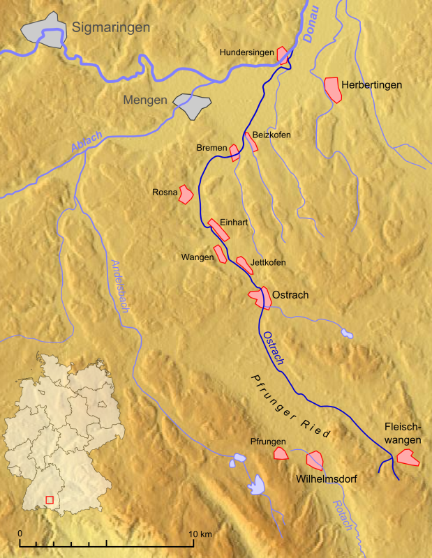
| Description | Verlaufskarte Ostrach |
| Date | |
| Source |
own work, used:
|
| Author | Lencer |

|
This map has been made or improved in the German Kartenwerkstatt (Map Lab). You can propose maps to improve as well.
|
This file is licensed under the Creative Commons Attribution-Share Alike 3.0 Unported license.
- You are free:
- to share – to copy, distribute and transmit the work
- to remix – to adapt the work
- Under the following conditions:
- attribution – You must give appropriate credit, provide a link to the license, and indicate if changes were made. You may do so in any reasonable manner, but not in any way that suggests the licensor endorses you or your use.
- share alike – If you remix, transform, or build upon the material, you must distribute your contributions under the same or compatible license as the original.
File history
Click on a date/time to view the file as it appeared at that time.
| Date/Time | Thumbnail | Dimensions | User | Comment | |
|---|---|---|---|---|---|
| current | 16:35, 17 December 2007 | | 619 × 800 (662 KB) | Lencer (talk | contribs) | {{Information| |Description=Verlaufskarte Ostrach |Source=own work, used: * 3rd Military Mapping Survey of Austria-Hungary (Kartenblatt 27-48 Konstanz) * [http://www.maps-for-free.com/ Google Map |
You cannot overwrite this file.
File usage on Commons
The following page uses this file:
File usage on other wikis
The following other wikis use this file:
- Usage on arz.wikipedia.org
- Usage on de.wikipedia.org
- Usage on en.wikipedia.org
- Usage on es.wikipedia.org
- Usage on www.wikidata.org