File:Vestfold grevskaper.jpg

Size of this preview: 409 × 599 pixels. Other resolutions: 164 × 240 pixels | 328 × 480 pixels | 524 × 768 pixels | 699 × 1,024 pixels | 2,442 × 3,575 pixels.
Original file (2,442 × 3,575 pixels, file size: 3.6 MB, MIME type: image/jpeg)
File information
Structured data
Captions
Captions
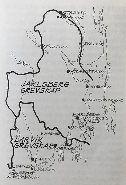
Map showing the borders of the former Norwegian counties of Laurvigen (Larvik) and Jarlsberg (Tønsberg).
Kart som viser grensene til de tidligere norske grevskapene Laurvigen (Larvik) og Jarlsberg (Tønsberg).
Summary edit
| DescriptionVestfold grevskaper.jpg |
English: A map showing the borders of the former Norwegian counties of Laurvigen and Jarlsberg. These two counties were the only traditional counties in Norway ruled by a count.
Norsk bokmål: Et kart som viser grensene til de tidligere norske grevskapene Laurvigen og Jarlsberg. Disse to grevskapene var de eneste grevskapene i Norge og var styrt av grever. |
|||||
| Date | ||||||
| Source | https://vestfoldmuseene.no/fordypning/opprettelsen-av-larvik-grevskap-i-1671/ | |||||
| Author | Tegning av Bjarne Stenberg etter forarbeid av Jørgen H. Marthinsen. Faksimile fra Vestfolds historie, Øystein Rian. | |||||
| Other versions |
|
Licensing edit
| This file is made available under the Creative Commons CC0 1.0 Universal Public Domain Dedication. | |
| The person who associated a work with this deed has dedicated the work to the public domain by waiving all of their rights to the work worldwide under copyright law, including all related and neighboring rights, to the extent allowed by law. You can copy, modify, distribute and perform the work, even for commercial purposes, all without asking permission.
http://creativecommons.org/publicdomain/zero/1.0/deed.enCC0Creative Commons Zero, Public Domain Dedicationfalsefalse |
File history
Click on a date/time to view the file as it appeared at that time.
| Date/Time | Thumbnail | Dimensions | User | Comment | |
|---|---|---|---|---|---|
| current | 11:27, 27 August 2020 |  | 2,442 × 3,575 (3.6 MB) | Worldlydev (talk | contribs) | Uploaded a work by Tegning av Bjarne Stenberg etter forarbeid av Jørgen H. Marthinsen. Faksimile fra Vestfolds historie, Øystein Rian. from https://vestfoldmuseene.no/fordypning/opprettelsen-av-larvik-grevskap-i-1671/ with UploadWizard |
You cannot overwrite this file.
File usage on Commons
The following page uses this file:
File usage on other wikis
The following other wikis use this file:
- Usage on no.wikipedia.org

