File:Via Belgica-kaart.png
No higher resolution available.
Via_Belgica-kaart.png (600 × 223 pixels, file size: 15 KB, MIME type: image/png)
Captions
Captions
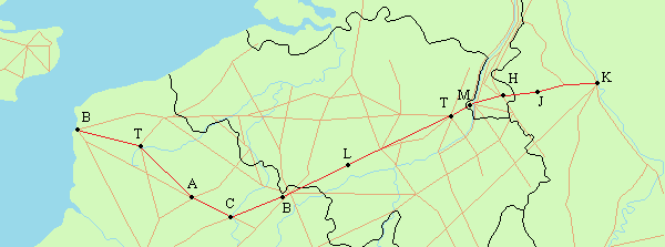
map of Roman road Via Belgica
Summary edit
| Description |
English: Map of Roman road Via Belgica
Nederlands: Kaart van de Romeinse weg "Via Belgica", met daarop: Boulogne-sur-Mer/Bonen (Gesoriacum), Thérouanne/Terwaan (Colonia Morinorum), Arras/Atrecht (Atrebatum), Cambrai/Kamerijk (Cameracum), Bavay/Beuken (Bagacum), Liberchies (Geminiacum), Tongeren (Atuatuca Tungrorum), Maastricht (Mosa Trajectum), Heerlen (Coriovallum), Jülich/Gulik (Iuliacum) en Keulen (Colonia Claudia Ara Agrippinensium). |
| Date | |
| Source | Own work |
| Author | Romaine |
Licensing edit
| This file is made available under the Creative Commons CC0 1.0 Universal Public Domain Dedication. | |
| The person who associated a work with this deed has dedicated the work to the public domain by waiving all of their rights to the work worldwide under copyright law, including all related and neighboring rights, to the extent allowed by law. You can copy, modify, distribute and perform the work, even for commercial purposes, all without asking permission.
|
File history
Click on a date/time to view the file as it appeared at that time.
| Date/Time | Thumbnail | Dimensions | User | Comment | |
|---|---|---|---|---|---|
| current | 23:33, 23 May 2010 | 600 × 223 (15 KB) | Romaine (talk | contribs) | Idem | |
| 23:24, 23 May 2010 | 600 × 223 (15 KB) | Romaine (talk | contribs) | {{Information |Description={{en|1=Map of Roman road Via Belgica}} {{nl|1=Kaart van de Romeinse weg Via Belgica}} |Source={{own}} |Author=Romaine |Date=2010-05-24 |Permission= |other_versions= }} Category:Via Belgica |
You cannot overwrite this file.
File usage on Commons
The following page uses this file:
File usage on other wikis
The following other wikis use this file:
- Usage on de.wikipedia.org
- Usage on it.wikipedia.org
- Usage on nl.wikipedia.org
- Taalgrens in België
- Tongeren (stad)
- Mosa Trajectum
- Geschiedenis van Maastricht
- Geschiedenis van Terwaan
- Via Belgica
- Portaal:Maastricht/Uit de geschiedenis
- Heirbaan Boulogne-Kassel-Keulen
- Portaal:Maastricht/Uit de geschiedenis/01
- Gebruiker:Croonstad/Test
- Gebruiker:DerekvG/Zandbak/Antwerps/Heirbaan dialecten
- Usage on www.wikidata.org