File:Via Egnatia-fr.jpg

Size of this preview: 733 × 600 pixels. Other resolutions: 293 × 240 pixels | 587 × 480 pixels | 939 × 768 pixels | 1,100 × 900 pixels.
Original file (1,100 × 900 pixels, file size: 422 KB, MIME type: image/jpeg)
Captions
Captions
Add a one-line explanation of what this file represents
Summary edit
| Description |
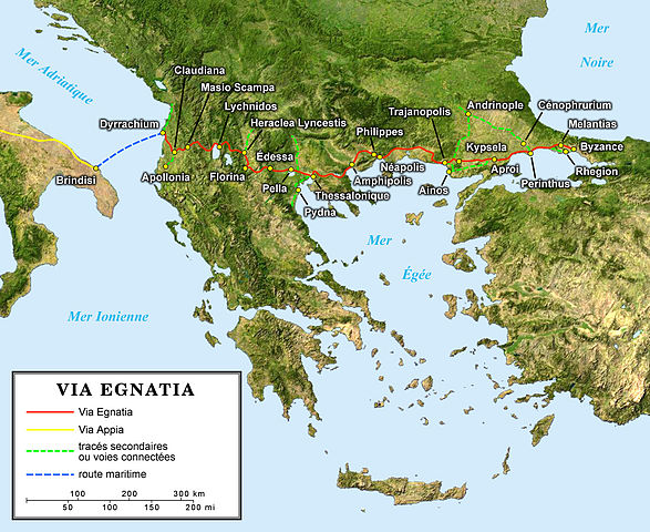
English: Map in French of the antic Roman Via Egnatia crossing the South of the Balkans.
Español: Mapa en francés de la antigua Vía Egnatia romana cruzando el sur de la península de los Balcanes.
Français : Carte en français de l'antique Via Egnatia romaine traversant le sud des Balkans. |
||
| Date | |||
| Source |
Own work; |
||
| Author | Eric Gaba (Sting - fr:Sting) | ||
| Permission (Reusing this file) |
|
||
| Other versions |
[]
|


Licensing edit
I, the copyright holder of this work, hereby publish it under the following license:
This file is licensed under the Creative Commons Attribution-Share Alike 2.5 Generic license.
- You are free:
- to share – to copy, distribute and transmit the work
- to remix – to adapt the work
- Under the following conditions:
- attribution – You must give appropriate credit, provide a link to the license, and indicate if changes were made. You may do so in any reasonable manner, but not in any way that suggests the licensor endorses you or your use.
- share alike – If you remix, transform, or build upon the material, you must distribute your contributions under the same or compatible license as the original.
File history
Click on a date/time to view the file as it appeared at that time.
| Date/Time | Thumbnail | Dimensions | User | Comment | |
|---|---|---|---|---|---|
| current | 22:36, 10 June 2006 | | 1,100 × 900 (422 KB) | Sting (talk | contribs) | {{Information |Description=Map of the antic Roman Via Egnatia crossing the South of the Balkans |Source=''For the source of data and the modern name of the cities, see the'' '''discussion page''' |Date |
You cannot overwrite this file.
File usage on Commons
The following 8 pages use this file:
File usage on other wikis
The following other wikis use this file:
- Usage on es.wikipedia.org
- Usage on fr.wikipedia.org
- Usage on la.wikipedia.org