File:Viceroyalty of the New Spain 1800 (without Philippines).png

Original file (1,600 × 1,192 pixels, file size: 645 KB, MIME type: image/png)
Captions
Captions

|
File:Mapa del Virreinato de la Nueva España (1794).svg is a vector version of this file. It should be used in place of this PNG file when not inferior.
File:Viceroyalty of the New Spain 1800 (without Philippines).png → File:Mapa del Virreinato de la Nueva España (1794).svg
For more information, see Help:SVG. |
.svg) |
Summary edit
| Description |
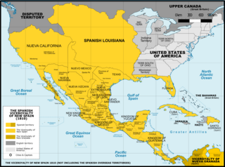
Español: Mapa del Virreinato de Nueva España en 1800. Sin incluir los territorios de ultramar en el Oceano Pacífico.
English: Map of the Viceroyalty of New Spain in 1800. Not including the viceroyalty's overseas territories in the Pacific Ocean.
Territorial organization of the Viceroyalty of New Spain (1535-1786)
Territorial organization of the Viceroyalty of New Spain (1786-1821)
|
||
| Date | |||
| Source |
A map created using information from the United States Geological Survey, an agency of the United States Department of Interior 1800, 1810, 1820 and from the Secretary of the Public Education of Mexico (Secretaría de Educación Pública de México) with 500 años de documentos COMMENT on 1 April 2015: The map above is still captioned "1810," instead of 1800. This is unfortunate and confusing, because in 1803 Spanish Louisiana was tranferred (to France and then) to the United States, so it makes the map appear to contain a serious error. ‘’’COMMENT on 13 August 2023: Date on the map above has still not been corrected to the actual year it represents, 1800. This leads to several inaccuracies, including for example misrepresentation of the size of the United States. In 1803 Ohio became a state, so it was no longer a territory by 1810. Such things were quickly changing in the 1800s, and the date on this map should be corrected.’’’ |
||
| Author | Giggette | ||
| Other versions |
|

.png)
.png)
.png&redirect=no)
.png&action=edit§ion=1)
| Camera location | | View this and other nearby images on: OpenStreetMap |
|---|
.png¶ms=019.409500_N_-099.130700_E_globe:Earth_type:camera_type:satellite_region:MX_heading:0.00&language=en)
Licensing edit
.png&action=edit§ion=2)
- You are free:
- to share – to copy, distribute and transmit the work
- to remix – to adapt the work
- Under the following conditions:
- attribution – You must give appropriate credit, provide a link to the license, and indicate if changes were made. You may do so in any reasonable manner, but not in any way that suggests the licensor endorses you or your use.
- share alike – If you remix, transform, or build upon the material, you must distribute your contributions under the same or compatible license as the original.

|
Permission is granted to copy, distribute and/or modify this document under the terms of the GNU Free Documentation License, Version 1.2 or any later version published by the Free Software Foundation; with no Invariant Sections, no Front-Cover Texts, and no Back-Cover Texts. A copy of the license is included in the section entitled GNU Free Documentation License. |
File history
Click on a date/time to view the file as it appeared at that time.
| Date/Time | Thumbnail | Dimensions | User | Comment | |
|---|---|---|---|---|---|
| current | 02:42, 21 November 2016 | | 1,600 × 1,192 (645 KB) | Giggette (talk | contribs) | Clearest |
| 20:14, 1 June 2014 |  | 1,600 × 1,192 (635 KB) | Giggette (talk | contribs) | Details | |
| 20:39, 13 May 2014 |  | 1,600 × 1,192 (634 KB) | Giggette (talk | contribs) | Details | |
| 20:34, 13 May 2014 |  | 1,450 × 1,080 (557 KB) | Giggette (talk | contribs) | Improving the design, adding elements | |
| 23:39, 11 May 2014 |  | 1,501 × 1,117 (549 KB) | Giggette (talk | contribs) | Adding details, lakes, cities, information | |
| 22:41, 11 May 2014 |  | 1,501 × 1,116 (538 KB) | Giggette (talk | contribs) | Adding missed provinces and clarifying information | |
| 17:54, 6 May 2014 |  | 1,501 × 1,116 (517 KB) | Giggette (talk | contribs) | Details | |
| 22:38, 4 May 2014 |  | 1,302 × 971 (450 KB) | Giggette (talk | contribs) | Details | |
| 17:33, 6 June 2013 |  | 1,450 × 1,084 (500 KB) | Giggette (talk | contribs) | mistake | |
| 17:30, 6 June 2013 |  | 1,450 × 1,084 (490 KB) | Giggette (talk | contribs) | {{Information |Description ={{en|1=x}} |Source ={{own}} |Author =Giggette |Date = |Permission = |other_versions = }} |
You cannot overwrite this file.
File usage on Commons
The following 11 pages use this file:
- User:Donald Trung/Partition of Mexico
- User:Giggette
- User:Giggette/cylindrical maps
- Commons:Graphic Lab/Map workshop/Archive/2021
- File:Mexico 1824 (equirectangular projection).png
- File:Second Mexican Empire (equirectangular projection).png
- File:Spanish Caribbean Islands in the American Viceroyalties 1600.png
- File:Viceroyalty of New Spain 1800 (without Philippines).png (file redirect)
- File:Viceroyalty of New Spain Location 1800 (without Philippines).png (file redirect)
- File:Viceroyalty of the New Spain 1800 (without Philippines).png
- File:Viceroyalty of the New Spain 1819 (without Philippines).png
.png)
.png)
.png&redirect=no)
File usage on other wikis
The following other wikis use this file:
- Usage on cs.wikipedia.org
- Usage on en.wikipedia.org
- Usage on fr.wikipedia.org
- Usage on gl.wikipedia.org
.png&oldid=843971277)