File:Victoria cadastral divisions.png
Size of this preview: 800 × 558 pixels. Other resolutions: 320 × 223 pixels | 640 × 446 pixels | 1,000 × 697 pixels.
Original file (1,000 × 697 pixels, file size: 133 KB, MIME type: image/png)
Captions
Captions
Add a one-line explanation of what this file represents

|
This locator map image could be re-created using vector graphics as an SVG file. This has several advantages; see Commons:Media for cleanup for more information. If an SVG form of this image is available, please upload it and afterwards replace this template with
{{vector version available|new image name}}.
It is recommended to name the SVG file “Victoria cadastral divisions.svg”—then the template Vector version available (or Vva) does not need the new image name parameter. |
Summary edit
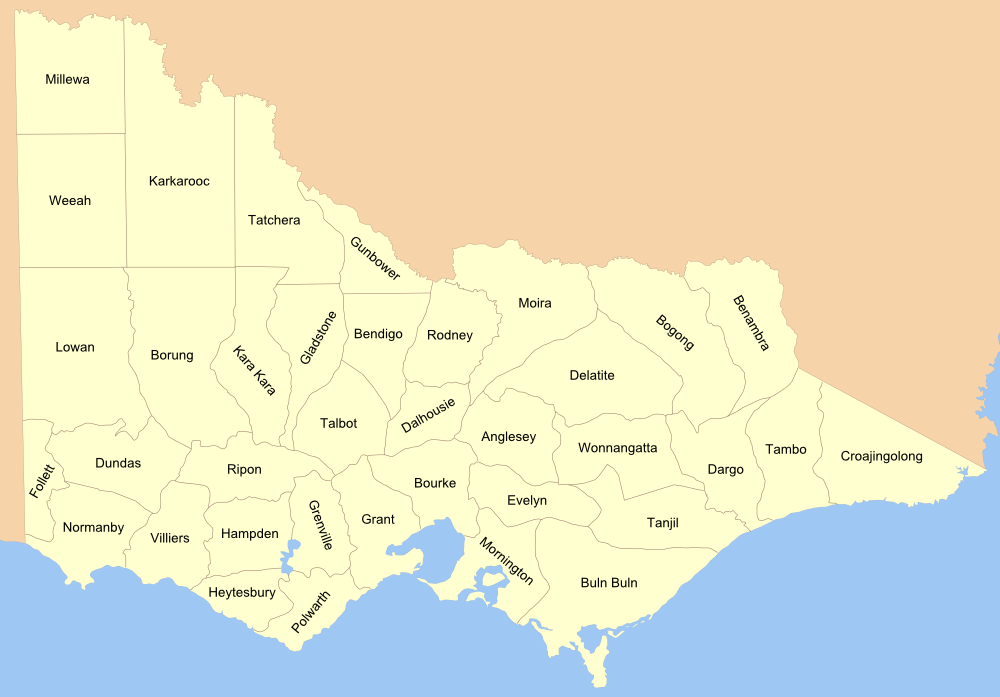
Map of the Counties of Victoria, see 1876 map from the National Library collection.
Licensing edit
I, the copyright holder of this work, hereby publish it under the following license:

|
Permission is granted to copy, distribute and/or modify this document under the terms of the GNU Free Documentation License, Version 1.2 or any later version published by the Free Software Foundation; with no Invariant Sections, no Front-Cover Texts, and no Back-Cover Texts. A copy of the license is included in the section entitled GNU Free Documentation License. |
| This file is licensed under the Creative Commons Attribution-Share Alike 3.0 Unported license. | ||
| ||
| This licensing tag was added to this file as part of the GFDL licensing update. |
File history
Click on a date/time to view the file as it appeared at that time.
| Date/Time | Thumbnail | Dimensions | User | Comment | |
|---|---|---|---|---|---|
| current | 11:57, 9 March 2007 | | 1,000 × 697 (133 KB) | Roke~commonswiki (talk | contribs) | islands, borders |
| 11:56, 8 March 2007 |  | 1,000 × 697 (122 KB) | Roke~commonswiki (talk | contribs) | Map of the Counties of Victoria, see [http://www.nla.gov.au/apps/cdview?pi=nla.map-f285-1 1876 map] from the National Library collection. Category:Maps of Victoria Category:Maps of the history of Australia |
You cannot overwrite this file.
File usage on Commons
There are no pages that use this file.
File usage on other wikis
The following other wikis use this file:
- Usage on en.wikipedia.org
- Usage on fr.wikipedia.org
- Usage on pt.wikipedia.org
- Usage on www.wikidata.org