File:View of Alden Park from the bandstand, showing polaris missile and building 46 in background; camera facing north. - Mare Island Naval Shipyard, East of Nave Drive, Vallejo, HABS CAL,48-MARI,1-44.tif

Size of this JPG preview of this TIF file: 481 × 599 pixels. Other resolutions: 193 × 240 pixels | 385 × 480 pixels | 616 × 768 pixels | 822 × 1,024 pixels | 1,644 × 2,048 pixels | 4,013 × 5,000 pixels.
Original file (4,013 × 5,000 pixels, file size: 19.14 MB, MIME type: image/tiff)
Captions
Captions
Add a one-line explanation of what this file represents
Summary edit
| View of Alden Park from the bandstand, showing polaris missile and building 46 in background; camera facing north. - Mare Island Naval Shipyard, East of Nave Drive, Vallejo, Solano County, CA | ||||
|---|---|---|---|---|
| Photographer |
Dewey, William |
|||
| Title |
View of Alden Park from the bandstand, showing polaris missile and building 46 in background; camera facing north. - Mare Island Naval Shipyard, East of Nave Drive, Vallejo, Solano County, CA |
|||
| Depicted place | California; Solano County; Vallejo | |||
| Date | 1998 | |||
| Dimensions | 4 x 5 in. | |||
| Current location |
Library of Congress Prints and Photographs Division Washington, D.C. 20540 USA http://hdl.loc.gov/loc.pnp/pp.print |
|||
| Accession number |
HABS CAL,48-MARI,1-44 |
|||
| Credit line |
|
|||
| Source | https://www.loc.gov/pictures/item/ca2540.photos.326605p | |||
| Permission (Reusing this file) |
|
|||

| Camera location | | View this and other nearby images on: OpenStreetMap |
|---|
File history
Click on a date/time to view the file as it appeared at that time.
| Date/Time | Thumbnail | Dimensions | User | Comment | |
|---|---|---|---|---|---|
| current | 06:23, 7 July 2014 | 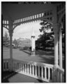 | 4,013 × 5,000 (19.14 MB) | Fæ (talk | contribs) | GWToolset: Creating mediafile for Fæ. HABS 05 July 2014 (401:500) |
You cannot overwrite this file.
File usage on Commons
The following page uses this file: