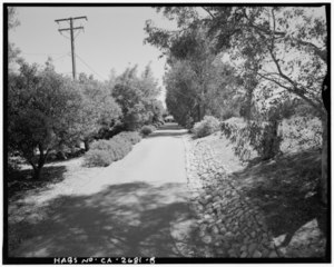
File:View of driveway with orchard on left, facing toward Goerlitz House. Camera facing 164" south-southeast. - Goerlitz House, 9893 Highland Avenue, Rancho Cucamonga, San HABS CAL,36-RANCU,2-5.tif

Size of this JPG preview of this TIF file: 750 × 600 pixels. Other resolutions: 300 × 240 pixels | 600 × 480 pixels | 960 × 768 pixels | 1,280 × 1,024 pixels | 2,560 × 2,047 pixels | 5,000 × 3,999 pixels.
Original file (5,000 × 3,999 pixels, file size: 19.07 MB, MIME type: image/tiff)
Captions
Captions
Add a one-line explanation of what this file represents
Summary edit
| View of driveway with orchard on left, facing toward Goerlitz House. Camera facing 164" south-southeast. - Goerlitz House, 9893 Highland Avenue, Rancho Cucamonga, San Bernardino County, CA | ||||
|---|---|---|---|---|
| Photographer |
Rittermann, Philipp |
|||
| Title |
View of driveway with orchard on left, facing toward Goerlitz House. Camera facing 164" south-southeast. - Goerlitz House, 9893 Highland Avenue, Rancho Cucamonga, San Bernardino County, CA |
|||
| Depicted place | California; San Bernardino County; Rancho Cucamonga | |||
| Date | 1997 | |||
| Dimensions | 4 x 5 in. | |||
| Current location |
Library of Congress Prints and Photographs Division Washington, D.C. 20540 USA http://hdl.loc.gov/loc.pnp/pp.print |
|||
| Accession number |
HABS CAL,36-RANCU,2-5 |
|||
| Credit line |
|
|||
| Source | https://www.loc.gov/pictures/item/ca2330.photos.376737p | |||
| Permission (Reusing this file) |
|
|||

| Camera location | | View this and other nearby images on: OpenStreetMap |
|---|
File history
Click on a date/time to view the file as it appeared at that time.
| Date/Time | Thumbnail | Dimensions | User | Comment | |
|---|---|---|---|---|---|
| current | 13:38, 6 July 2014 |  | 5,000 × 3,999 (19.07 MB) | Fæ (talk | contribs) | GWToolset: Creating mediafile for Fæ. HABS 05 July 2014 (401:500) |
You cannot overwrite this file.
File usage on Commons
The following page uses this file: