File:Vimy-Sheet36c SW3 Edition 8a 10-02-17.jpg

Size of this preview: 800 × 591 pixels. Other resolutions: 320 × 236 pixels | 640 × 473 pixels | 1,024 × 756 pixels | 1,280 × 945 pixels | 2,560 × 1,890 pixels | 21,931 × 16,193 pixels.
Original file (21,931 × 16,193 pixels, file size: 69.75 MB, MIME type: image/jpeg)
Captions
Captions
Add a one-line explanation of what this file represents
Summary edit
| Warning | The original file is very high-resolution. It might not load properly or could cause your browser to freeze when opened at full size. |
|---|
| Description |
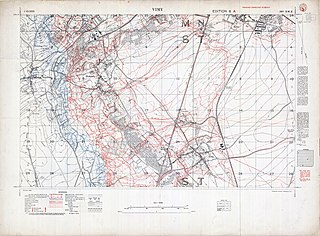
English: German trenches and names in red; British trenches to depth of 500 yards and names blue; many named mine craters; the northern end of the Vimy Ridge |
||||||||||||||||||||
| Date | |||||||||||||||||||||
| Source | McMaster University, Fonds: WW1 Trench Maps: France, Box number: PC03; envelope_number: 77 | ||||||||||||||||||||
| Creator |
War Office. General Staff. Geographical Section, Field Service Battalion, Royal Engineers |
||||||||||||||||||||
| Permission (Reusing this file) |
|
||||||||||||||||||||
| Geotemporal data | |||||||||||||||||||||
| Date depicted | |||||||||||||||||||||
| Map location | Vimy | ||||||||||||||||||||
| Map type | trench map | ||||||||||||||||||||
| Scale | 1:10,000 | ||||||||||||||||||||
| Heading |
 |
||||||||||||||||||||
| Georeferencing | If inappropriate please set warp_status = skip to hide. | ||||||||||||||||||||
| Bibliographic data | |||||||||||||||||||||
| Map sheet | 36c SW3 | ||||||||||||||||||||
| Language | English | ||||||||||||||||||||
| Publisher |
Royal Engineers |
||||||||||||||||||||
| Archival data | |||||||||||||||||||||
| Collection |
|
||||||||||||||||||||


File history
Click on a date/time to view the file as it appeared at that time.
| Date/Time | Thumbnail | Dimensions | User | Comment | |
|---|---|---|---|---|---|
| current | 03:15, 4 March 2019 | | 21,931 × 16,193 (69.75 MB) | Labattblueboy (talk | contribs) | colour profile |
| 23:42, 3 March 2019 |  | 21,931 × 16,193 (69.68 MB) | Labattblueboy (talk | contribs) | straighten, cropped, colour balanced | |
| 23:01, 3 March 2019 |  | 22,104 × 16,243 (50.35 MB) | Labattblueboy (talk | contribs) | {{Information |description ={{en|1=German trenches and names in red; British trenches to depth of 500 yards and names blue; many named mine craters; the northern end of the Vimy Ridge}} |date =2017-02-10 |source =McMaster University, Fonds: WW1 Trench Maps: France, Box number: PC03; envelope_number: 77 |author =War Office. General Staff. Geographical Section, Field Service Battalion, Royal Engineers |permission ={{OldOS}}{{PD-UKGov}}{{PD-1923}} }} |
You cannot overwrite this file.
File usage on Commons
The following page uses this file: