File:Virginia geographic map-en.svg

Size of this PNG preview of this SVG file: 800 × 439 pixels. Other resolutions: 320 × 176 pixels | 640 × 352 pixels | 1,024 × 562 pixels | 1,280 × 703 pixels | 2,560 × 1,406 pixels | 3,641 × 2,000 pixels.
Original file (SVG file, nominally 3,641 × 2,000 pixels, file size: 12.5 MB)
Captions
Captions
Add a one-line explanation of what this file represents
Summary edit
| Description |
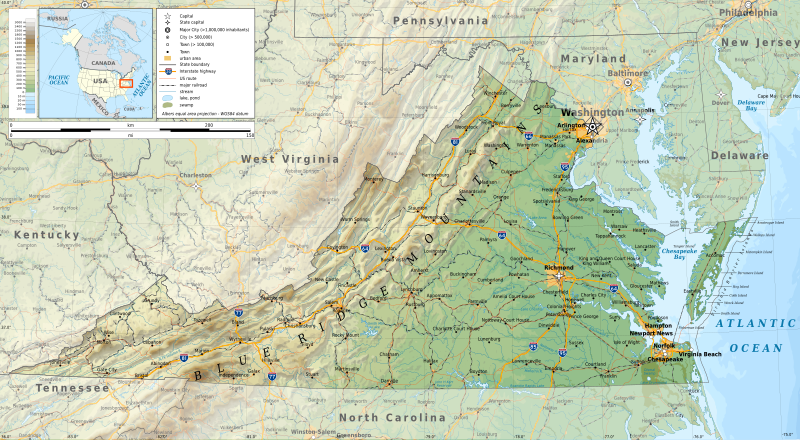
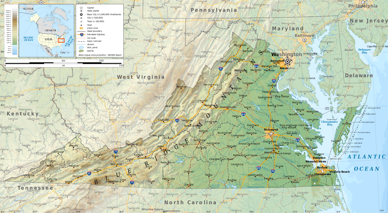
English: Geographic map of Virginia in English. Geographic limits of the map:
|
| Date | |
| Source |
Own work
|
| Author | Ikonact |
| Permission (Reusing this file) |
Any use of this map is subject of the license(s) stated below with the condition that you credit (Wikimedia Commons user: Ikonact) as the author . A message with a reply address would also be greatly appreciated. |

|
This SVG file contains embedded text that can be translated into your language, using any capable SVG editor, text editor or the SVG Translate tool. For more information see: About translating SVG files. |
Licensing edit
I, the copyright holder of this work, hereby publish it under the following license:
This file is licensed under the Creative Commons Attribution-Share Alike 4.0 International license.
- You are free:
- to share – to copy, distribute and transmit the work
- to remix – to adapt the work
- Under the following conditions:
- attribution – You must give appropriate credit, provide a link to the license, and indicate if changes were made. You may do so in any reasonable manner, but not in any way that suggests the licensor endorses you or your use.
- share alike – If you remix, transform, or build upon the material, you must distribute your contributions under the same or compatible license as the original.
File history
Click on a date/time to view the file as it appeared at that time.
| Date/Time | Thumbnail | Dimensions | User | Comment | |
|---|---|---|---|---|---|
| current | 10:08, 16 September 2019 | | 3,641 × 2,000 (12.5 MB) | Ikonact (talk | contribs) | valid svg |
| 08:37, 16 September 2019 |  | 3,641 × 2,000 (12.59 MB) | Ikonact (talk | contribs) | swamp pattern removed... librsvg bug with handling patterns at small sized pictures | |
| 22:08, 15 September 2019 |  | 3,641 × 2,000 (13.38 MB) | Ikonact (talk | contribs) | some font issues | |
| 21:48, 15 September 2019 |  | 3,641 × 2,000 (13.38 MB) | Ikonact (talk | contribs) | names added, size changed | |
| 22:08, 13 September 2019 |  | 5,461 × 3,000 (12.2 MB) | Ikonact (talk | contribs) | =={{int:filedesc}}== {{Information |description={{en|1=Geographic map of Virginia. Geographic limits of the map:}} *N: 39.98° N *S: 36.00° N *W: 83.75° W *E: 74.80° W Albers equal area projection; WGS 84 datum |date=2019-09-14 |source={{own}} *Sources of data:<br/> **Topography: ETOPO1 (public domain);<br/> **Public domain data provided by the National Atlas of the United States of America;<br/> *Tool:<br/> **The map is created with Octave scripts developed by Ikonact |author... |
You cannot overwrite this file.
File usage on Commons
More than 100 pages use this file. The following list shows the first 100 pages that use this file only. A full list is available.
- Virginia
- Category:1862 in Virginia
- Category:1865 in Virginia
- Category:1866 in Virginia
- Category:1895 in Virginia
- Category:1905 in Virginia
- Category:1918 in Virginia
- Category:1921 in Virginia
- Category:1922 in Virginia
- Category:1924 in Virginia
- Category:1937 in Virginia
- Category:1938 in Virginia
- Category:1942 in Virginia
- Category:1943 in Virginia
- Category:1944 in Virginia
- Category:1945 in Virginia
- Category:1949 in Virginia
- Category:1962 in Virginia
- Category:1966 in Virginia
- Category:1967 in Virginia
- Category:1992 in Virginia
- Category:1993 in Virginia
- Category:1999 in Virginia
- Category:2001 in Virginia
- Category:2005 in Virginia
- Category:2006 in Virginia
- Category:2007 in Virginia
- Category:2008 in Virginia
- Category:2009 in Virginia
- Category:2010 in Virginia
- Category:2011 in Virginia
- Category:Airports in Virginia
- Category:Archaeological sites in Virginia
- Category:Baseball in Virginia
- Category:Basketball players from Virginia
- Category:Bays of Virginia
- Category:Beaches of Virginia
- Category:Bodies of water in Virginia
- Category:Bridges in Virginia
- Category:Canals in Virginia
- Category:Caves of Virginia
- Category:Cemeteries in Virginia
- Category:Cities in Virginia
- Category:Courthouses in Virginia
- Category:Dams in Virginia
- Category:Energy in Virginia
- Category:Flora of Virginia
- Category:Hospitals in Virginia
- Category:Islands of Virginia
- Category:Lakes of Virginia
- Category:Libraries in Virginia
- Category:Lighthouses in Virginia
- Category:Maps of Virginia
- Category:Mountains of Virginia
- Category:National Forests of Virginia
- Category:National Historic Landmarks in Virginia
- Category:Parks in Virginia
- Category:Plantations in Virginia
- Category:Rail transport in Virginia
- Category:Railway bridges in Virginia
- Category:Rivers of Virginia
- Category:Schools in Virginia
- Category:Shopping malls in Virginia
- Category:Sports venues in Virginia
- Category:Towers in Virginia
- Category:Towns in Virginia
- Category:Tunnels in Virginia
- Category:Unincorporated communities in Virginia
- Category:Valleys of Virginia
- Category:Virginia
- Category:Virginia by decade
- Category:Virginia in the 1720s
- Category:Virginia in the 1750s
- Category:Virginia in the 1770s
- Category:Virginia in the 1780s
- Category:Virginia in the 1790s
- Category:Virginia in the 1810s
- Category:Virginia in the 1820s
- Category:Virginia in the 1830s
- Category:Virginia in the 1850s
- Category:Virginia in the 1860s
- Category:Virginia in the 1870s
- Category:Virginia in the 1880s
- Category:Virginia in the 1890s
- Category:Virginia in the 18th century
- Category:Virginia in the 1900s
- Category:Virginia in the 1910s
- Category:Virginia in the 1920s
- Category:Virginia in the 1930s
- Category:Virginia in the 1940s
- Category:Virginia in the 1950s
- Category:Virginia in the 1960s
- Category:Virginia in the 1970s
- Category:Virginia in the 1980s
- Category:Virginia in the 1990s
- Category:Virginia in the 19th century
- Category:Virginia in the 2000s
- Category:Virginia in the 2010s
- Category:Virginia in the 20th century
- Category:Virginia in the 21st century
View more links to this file.
File usage on other wikis
The following other wikis use this file:
- Usage on ang.wikipedia.org
- Usage on be.wikipedia.org
- Usage on bg.wikipedia.org
- Usage on ca.wikipedia.org
- Usage on en.wikipedia.org
- Usage on ga.wikipedia.org
- Usage on gl.wikipedia.org
- Usage on hu.wikipedia.org
- Usage on hy.wikipedia.org
- Usage on lt.wikipedia.org
- Usage on mhr.wikipedia.org
- Usage on os.wikipedia.org
- Usage on ru.wikipedia.org
- Usage on tg.wikipedia.org
- Usage on tt.wikipedia.org
- Usage on www.wikidata.org