File:Virginiae partis australis, et Floridae partis orientalis, interjacentiumq(ue) regionum nova descriptio. NYPL434011.tiff

Size of this JPG preview of this TIF file: 641 × 600 pixels. Other resolutions: 257 × 240 pixels | 513 × 480 pixels | 821 × 768 pixels | 1,095 × 1,024 pixels | 2,189 × 2,048 pixels | 4,344 × 4,064 pixels.
Original file (4,344 × 4,064 pixels, file size: 50.55 MB, MIME type: image/tiff)
Captions
Captions
Add a one-line explanation of what this file represents
Summary edit
| Description | Virginiae partis australis, et Floridae partis orientalis, interjacentiumq[ue] regionum nova descriptio.; Lawrence H. Slaughter Collection of English maps, charts, globes, books and atlases / Charts and maps | |||||||||||||||||||||||
| Notes | Bar scale above the neat line on the lower margin: Milliaria Germanica communia. ''Note 2.'') Covers Atlantic Coast from Virginia to Florida. ''Note 3.'') Descriptive text on verso: Florida. Catchword: vrouwen. On upper right corner: [p.] 28. ''Note 4.'') Includes decorative cartouche and coat of arms. ''Note 5.'') Lawrence H. Slaughter Collection ; 356. ''Note 6.'') National Endowment for the Humanities Grant for Access to Early Maps of the Middle Atlantic Seaboard. ''Note 7.'') Prime meridian: [Ferro]. ''Note 8.'') Relief shown pictorially. ''Note 9.'') From Blaeu's Toonneel des aerdriicx, ofte nievwe atlas. | |||||||||||||||||||||||
| Item physical description | 1 map : hand col. ; 38 x 49 cm. | |||||||||||||||||||||||
| Catalogue call number | Map Div. 01-5101 [Filed with Virginia 1630, as originally cataloged in NYPL Dictionary Catalog of the Map Division] | |||||||||||||||||||||||
| Standard reference | Cumming. Southeast in early maps, 41; Koeman, C. Atlantes Neerlandici, I; Burden, P.D. Mapping of America, 253 | |||||||||||||||||||||||
| Date | circa 1638 | |||||||||||||||||||||||
| Source |
http://digitalgallery.nypl.org/nypldigital/dgkeysearchdetail.cfm?imageID=434011
|
|||||||||||||||||||||||
| Author | Willem Janszoon, 1571-1638 -- Cartographer Blaeu | |||||||||||||||||||||||
| Permission (Reusing this file) |
From The Lionel Pincus and Princess Firyal Map Division. http://maps.nypl.org
|
|||||||||||||||||||||||
| Location | Stephen A. Schwarzman Building / The Lionel Pincus and Princess Firyal Map Division | |||||||||||||||||||||||
| Digital item published | 2-3-2004; updated 3-25-2011 | |||||||||||||||||||||||
| Digital ID | 434011 | |||||||||||||||||||||||

The making of this file was supported by Wikimedia UK.
To see other files made with the support of Wikimedia UK, please see the category Supported by Wikimedia UK.
|
File history
Click on a date/time to view the file as it appeared at that time.
| Date/Time | Thumbnail | Dimensions | User | Comment | |
|---|---|---|---|---|---|
| current | 17:42, 19 February 2016 |  | 4,344 × 4,064 (50.55 MB) | SteinsplitterBot (talk | contribs) | Bot: Image rotated by 270° |
| 08:19, 7 May 2014 | 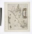 | 4,064 × 4,344 (50.52 MB) | Fæ (talk | contribs) | GWToolset: Creating mediafile for Fæ. Tranche 4 -4989 restart @08:55 BST, 7 May 2014 |
You cannot overwrite this file.
File usage on Commons
There are no pages that use this file.