File:Visualize historical hurricane tracks.tiff

Size of this PNG preview of this TIF file: 800 × 573 pixels. Other resolutions: 320 × 229 pixels | 640 × 458 pixels | 1,024 × 733 pixels | 1,280 × 917 pixels | 2,276 × 1,630 pixels.
Original file (2,276 × 1,630 pixels, file size: 14.16 MB, MIME type: image/tiff)
Captions
Captions
Add a one-line explanation of what this file represents
Summary edit
| Description |
English: NOAA’s Coastal Services Center has redesigned an online map tool for visualizing the tracks of historical hurricanes
Español: El centro de servicio costanero NOAA a remodelado su herramienta en la web para trazar las rutas de hurracanes históricos. |
| Date | |
| Source | NOAA in the Caribbean http://www.regions.noaa.gov/secar/wp-content/uploads/2013/06/NOAA-Carib-Newsletter-Volume-3-Issue-1-2014-October.pdf |
| Author | NOAA |
Licensing edit
This image is in the public domain because it contains materials that originally came from the U.S. National Oceanic and Atmospheric Administration, taken or made as part of an employee's official duties.
|
File history
Click on a date/time to view the file as it appeared at that time.
| Date/Time | Thumbnail | Dimensions | User | Comment | |
|---|---|---|---|---|---|
| current | 10:01, 11 February 2016 | 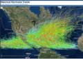 | 2,276 × 1,630 (14.16 MB) | Caballero1967 (talk | contribs) | User created page with UploadWizard |
You cannot overwrite this file.
File usage on Commons
There are no pages that use this file.
File usage on other wikis
The following other wikis use this file:
- Usage on nds.wikipedia.org