File:Vorpommern physisch.png

Size of this preview: 542 × 599 pixels. Other resolutions: 217 × 240 pixels | 434 × 480 pixels | 951 × 1,051 pixels.
Original file (951 × 1,051 pixels, file size: 175 KB, MIME type: image/png)
Captions
Captions
Add a one-line explanation of what this file represents
Summary
edit
| Description |
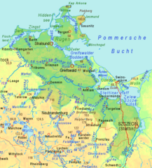
English: Relief map of Western Pomerania:
Brown figures = soil above sea level in meters (measure at the point, name above or below) dark blue figures = water level above sea level in meters dark blue arrows = direction of water flow, emphasized rivers drawn in stronger colours, lilac = water bodies crossing divides Deutsch: Physische Karte von Vorpommern: braune Zahlen = Höhen über NHN (Zahl auf Höhenpunkt, Name darüber oder darunter) dunkelblaue Zahlen = Wasserspiegel über HN dunkelblaue Pfeile = Strömungsrichtung, thematisierte Flüsse in kräftigeren Farben, lila = Gewässer kreuzt Wasserscheide. |
| Source |
Adapted cut of Image:Mecklenburg-Vorpommern.gif , created by myself in 2008 using http://www.maps-for-free.html |
| Author | Ulamm (talk) 18:57, 22 November 2013 (UTC) |
Licensing
edit
This file is licensed under the Creative Commons Attribution-Share Alike 3.0 Unported license.
- You are free:
- to share – to copy, distribute and transmit the work
- to remix – to adapt the work
- Under the following conditions:
- attribution – You must give appropriate credit, provide a link to the license, and indicate if changes were made. You may do so in any reasonable manner, but not in any way that suggests the licensor endorses you or your use.
- share alike – If you remix, transform, or build upon the material, you must distribute your contributions under the same or compatible license as the original.
File history
Click on a date/time to view the file as it appeared at that time.
| Date/Time | Thumbnail | Dimensions | User | Comment | |
|---|---|---|---|---|---|
| current | 17:01, 22 November 2013 | | 951 × 1,051 (175 KB) | Ulamm (talk | contribs) | == {{int:filedesc}} == {{Information |Description={{en|1=Relief map of Western Pomerania:<br>Brown figures = soil above sea level in meters (measure at the point, name above or below)<br>dark blue figures = water level above sea level in meters<br>dark... |
You cannot overwrite this file.
File usage on Commons
There are no pages that use this file.
File usage on other wikis
The following other wikis use this file:
- Usage on dsb.wikipedia.org
- Usage on pl.wikipedia.org
- Usage on pl.wiktionary.org
- Usage on sv.wikipedia.org