File:Vue aerienne de Quebec - 1945.jpg
Vue_aerienne_de_Quebec_-_1945.jpg (720 × 580 pixels, file size: 145 KB, MIME type: image/jpeg)
Captions
Captions
Summary edit
| Description |
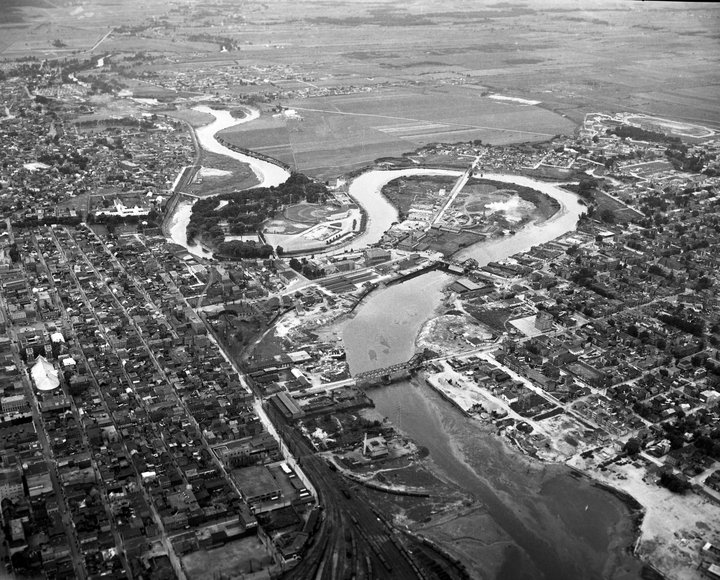
Français : Vue aérienne de Québec en 1945. Remarquez les ponts à bascule, le méandre de la rivière Saint-Charles qui ne disparaîtra qu’à partir de 1955, l’hospice Saint-Charles (hôpital de la Marine) près du pont Drouin, le marché Saint-Roch voisin, les ruines de l’aréna du parc Victoria détruit par les flammes le 30 juin 1942 et le stade municipal construit en 1938. Photo avec Aréna en ruines - Hôpital de la Marine - Marché Saint-Roch, Pont Dorchester, Pointe-aux-Lièvres, Pont Drouin et Rivière Lairet. |
| Date | |
| Source | * - facebook.com |
| Author | Fonds W.B. Edwards, Archives de la Ville de Québec. |
| Other versions |
 |
Licensing edit
This work is in the public domain in the United States because it meets three requirements:
For background information, see the explanations on Non-U.S. copyrights.
Note: This tag should not be used for sound recordings. |
This Canadian work is in the public domain in Canada because its copyright has expired due to one of the following:
it was not subject to Crown copyright, and
|
 |
File history
Click on a date/time to view the file as it appeared at that time.
| Date/Time | Thumbnail | Dimensions | User | Comment | |
|---|---|---|---|---|---|
| current | 12:04, 6 August 2016 | | 720 × 580 (145 KB) | Jeangagnon (talk | contribs) | {{Information |Description ={{fr|1=Vue aérienne de Québec en 1945. Remarquez les ponts à bascule, le méandre de la rivière Saint-Charles qui ne disparaîtra qu’à partir de 1955, l’hospice Saint-Charles (hôpital de la Marine) près du pont... |
You cannot overwrite this file.
File usage on Commons
The following 2 pages use this file:
File usage on other wikis
The following other wikis use this file:
- Usage on fr.wikipedia.org