File:WFA map showing fire spots ESA238558.tiff

Size of this PNG preview of this TIF file: 790 × 600 pixels. Other resolutions: 316 × 240 pixels | 632 × 480 pixels | 922 × 700 pixels.
Original file (922 × 700 pixels, file size: 955 KB, MIME type: image/tiff)
Captions
Captions
Add a one-line explanation of what this file represents
Summary edit
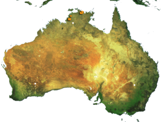
| Description |
English: Crop of the map produced on 20 June 2006 through ESA's ATSR World Fire Atlas (WFA). Red dots indicate fire spots as detected by Envisat’s Advanced Along Track Scanning Radiometer (AATSR) instrument. |
| Date | |
| Source | http://www.esa.int/spaceinimages/Images/2006/06/WFA_map_showing_fire_spots |
| Author | European Space Agency |
| Permission (Reusing this file) |
ESA,CC BY-SA 3.0 IGO |
| Other versions |
|
| Title | WFA map showing fire spots |
| Keywords | Environment; Environment hazards; Resource management; Fires |
| Mission | Envisat |
| Activity | Observing the Earth |

Licensing edit
This file is licensed under the Creative Commons Attribution-ShareAlike 3.0 IGO license.
Attribution: ESA
- You are free:
- to share – to copy, distribute and transmit the work
- to remix – to adapt the work
- Under the following conditions:
- attribution – You must give appropriate credit, provide a link to the license, and indicate if changes were made. You may do so in any reasonable manner, but not in any way that suggests the licensor endorses you or your use.
- share alike – If you remix, transform, or build upon the material, you must distribute your contributions under the same or compatible license as the original.
File history
Click on a date/time to view the file as it appeared at that time.
| Date/Time | Thumbnail | Dimensions | User | Comment | |
|---|---|---|---|---|---|
| current | 20:37, 24 May 2017 |  | 922 × 700 (955 KB) | Fæ (talk | contribs) | European Space Agency, Id 238558, http://www.esa.int/spaceinimages/Images/2006/06/WFA_map_showing_fire_spots, User:Fæ/Project_list/ESA |
You cannot overwrite this file.
File usage on Commons
The following page uses this file: