File:WSMR trial route map.png

Size of this preview: 776 × 599 pixels. Other resolutions: 311 × 240 pixels | 622 × 480 pixels | 994 × 768 pixels | 1,280 × 989 pixels | 1,393 × 1,076 pixels.
Original file (1,393 × 1,076 pixels, file size: 96 KB, MIME type: image/png)
Captions
Captions
Add a one-line explanation of what this file represents
Summary edit
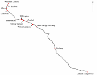
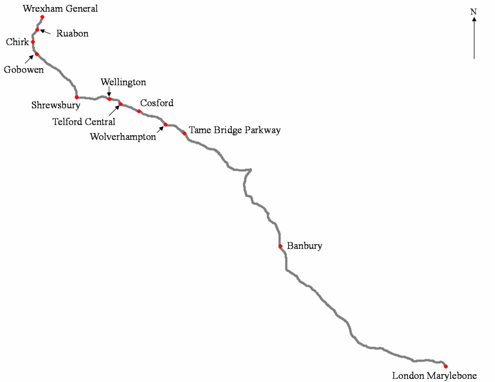
| Description | This is a route map for use on Wrexham & Shropshire (Wrexham, Shropshire and Marylebone Railway), showing the geographic location. The scale is 1:1000000 (or 10cm = 50 miles). |
| Date | 12 December 2006 (original upload date) |
| Source | Transferred from en.wikipedia to Commons by Simply south. |
| Author | Simply south at English Wikipedia |
Licensing edit
Simply south at the English-language Wikipedia, the copyright holder of this work, hereby publishes it under the following license:
| This file is licensed under the Creative Commons Attribution-Share Alike 3.0 Unported license. Subject to disclaimers. | ||
| Attribution: Simply south at the English-language Wikipedia | ||
| ||
| This licensing tag was added to this file as part of the GFDL licensing update. |

|
Permission is granted to copy, distribute and/or modify this document under the terms of the GNU Free Documentation License, Version 1.2 or any later version published by the Free Software Foundation; with no Invariant Sections, no Front-Cover Texts, and no Back-Cover Texts. A copy of the license is included in the section entitled GNU Free Documentation License. Subject to disclaimers. |
Original upload log edit
The original description page was here. All following user names refer to en.wikipedia.
- 2008-03-22 23:42 Simply south 1393×1076×8 (98334 bytes) still more minor formatting.
- 2008-03-22 23:37 Simply south 1393×1076×8 (98130 bytes) some minor formatting (sigh)
- 2008-03-22 19:28 Simply south 1393×1076×8 (98148 bytes) see before - text at font 14
- 2008-03-22 18:29 Simply south 1393×1076×8 (95983 bytes) This is probably the best version. The lines are possibly thick again with a slighly different shade of grey. The stations have all been repositioned to show as close as possible their geographic location. A North arrow has been added. This possibly has o
- 2008-03-21 22:39 Simply south 1234×827×8 (74735 bytes) This is a modified version that is cleaner and slightly more accurate in terms of route especially distances. Much of the route has updated (except it does not show which stations are pick-up\set down). Again, this map is not to scale.
- 2007-08-16 12:47 Simply south 1189×916×8 (74602 bytes) Updated version. still not to scale
- 2006-12-12 00:20 Simply south 1704×1320×8 (60724 bytes) Trial route pic. Not to Scale
File history
Click on a date/time to view the file as it appeared at that time.
| Date/Time | Thumbnail | Dimensions | User | Comment | |
|---|---|---|---|---|---|
| current | 19:26, 11 April 2008 | | 1,393 × 1,076 (96 KB) | File Upload Bot (Magnus Manske) (talk | contribs) | {{BotMoveToCommons|en.wikipedia}} {{Information |Description={{en|This is a route map for use on en:Wrexham & Shropshire (Wrexham, Shropshire and Marylebone Railway), showing the geographic location. The scale is 1:1000000 (or 10cm = 50 miles).}} |S |
You cannot overwrite this file.
File usage on Commons
The following page uses this file:
- File:Wrexham & Shropshire trial route map.png (file redirect)
File usage on other wikis
The following other wikis use this file:
- Usage on jbo.wikipedia.org