File:Waldseemuller map, complete.jpg

Original file (29,700 × 16,500 pixels, file size: 97.97 MB, MIME type: image/jpeg)
Captions
Captions
| Warning | The original file is very high-resolution. It might not load properly or could cause your browser to freeze when opened at full size. |
|---|
Summary edit
| Description |
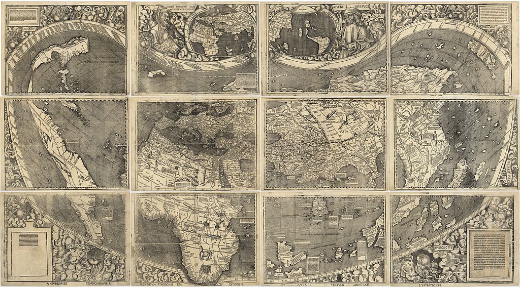
The Waldseemüller map, the first map to include the name "America" and the first to depict the Americas as separate from Asia. The map comprises 12 separate sheets, shown here into a single image. There is only one surviving copy of the map, which was purchased by the Library of Congress in 2001 for $10 million. Its Latin title is "Universalis cosmographia secundum Ptholomaei traditionem et Americi Vespucii alioru[m]que lustrationes". Converted from the LoC's JPEG2000 file to JPEG using ImageMagick with 81% quality (to fit under the current 100MB upload limit on Wikimedia Commons). |
|||||||||||||||||||||||
| Date | ||||||||||||||||||||||||
| Source | file, description. | |||||||||||||||||||||||
| Author |
|
|||||||||||||||||||||||
| Other versions |
|
|||||||||||||||||||||||


Licensing edit
|
This work is in the public domain in its country of origin and other countries and areas where the copyright term is the author's life plus 100 years or fewer. | |
| This file has been identified as being free of known restrictions under copyright law, including all related and neighboring rights. | |
File history
Click on a date/time to view the file as it appeared at that time.
| Date/Time | Thumbnail | Dimensions | User | Comment | |
|---|---|---|---|---|---|
| current | 00:06, 26 May 2011 | | 29,700 × 16,500 (97.97 MB) | Avenue (talk | contribs) | {{LargeImage}} == {{int:filedesc}} == {{Information |Description=The Waldseemüller map, the first map to include the name "America" and the first to depict the Americas as separate from Asia. The map comprises 12 separate she |
You cannot overwrite this file.
File usage on Commons
The following 5 pages use this file: