File:Warszawa - Linia metra M1.svg

Size of this PNG preview of this SVG file: 502 × 599 pixels. Other resolutions: 201 × 240 pixels | 402 × 480 pixels | 644 × 768 pixels | 858 × 1,024 pixels | 1,716 × 2,048 pixels | 616 × 735 pixels.
Original file (SVG file, nominally 616 × 735 pixels, file size: 232 KB)
Captions
Captions
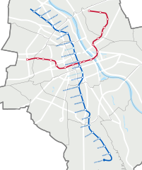
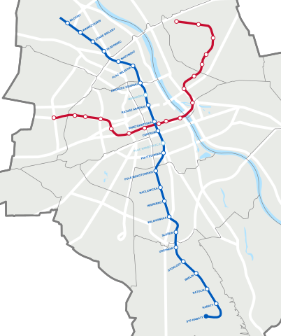
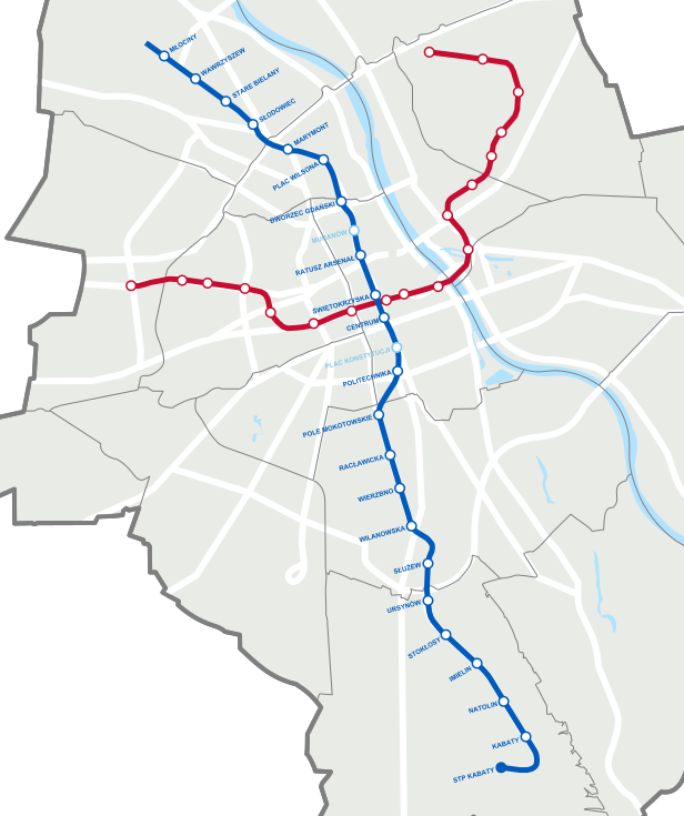
Plan of the 1st line of Warsaw Metro
Summary edit
| Description |
Polski: Mapa Warszawy z zaznaczoną linią metra M1.
This file was derived from: Warszawa outline with districts v4.svg |
| Date | |
| Source | Own work |
| Author | Jakub Murat |
Licensing edit
I, the copyright holder of this work, hereby publish it under the following license:
This file is licensed under the Creative Commons Attribution-Share Alike 4.0 International license.
- You are free:
- to share – to copy, distribute and transmit the work
- to remix – to adapt the work
- Under the following conditions:
- attribution – You must give appropriate credit, provide a link to the license, and indicate if changes were made. You may do so in any reasonable manner, but not in any way that suggests the licensor endorses you or your use.
- share alike – If you remix, transform, or build upon the material, you must distribute your contributions under the same or compatible license as the original.
File history
Click on a date/time to view the file as it appeared at that time.
| Date/Time | Thumbnail | Dimensions | User | Comment | |
|---|---|---|---|---|---|
| current | 08:49, 30 September 2022 | | 616 × 735 (232 KB) | Szczureq (talk | contribs) | aktualizacja |
| 21:09, 1 July 2022 |  | 616 × 735 (230 KB) | Szczureq (talk | contribs) | akt. | |
| 09:08, 4 April 2020 |  | 616 × 735 (228 KB) | Szczureq (talk | contribs) | odcinek wolski M2 otwarty | |
| 11:35, 20 September 2019 |  | 616 × 735 (226 KB) | Szczureq (talk | contribs) | korekta przebiegu M2 | |
| 14:06, 15 September 2019 |  | 616 × 735 (227 KB) | Szczureq (talk | contribs) | linia M2 wydłużona | |
| 21:29, 20 August 2017 |  | 616 × 735 (225 KB) | Boston9 (talk | contribs) | Reverted to version as of 20:37, 19 November 2015 (UTC) wrong - these stations should stay | |
| 16:34, 20 August 2017 |  | 616 × 735 (210 KB) | Aight 2009 (talk | contribs) | usunięcie nieplanowanych już stacji | |
| 20:37, 19 November 2015 |  | 616 × 735 (225 KB) | Muri 91 (talk | contribs) | Białe tło. | |
| 17:27, 19 November 2015 |  | 616 × 735 (225 KB) | Muri 91 (talk | contribs) | Nazwy stacji bez oznaczeń i na ścieżkach, plany związane z daną linią, tylko istniejące odcinki i stacje innych linii, przezroczysta mapa, drogi nad wodą. | |
| 16:03, 18 November 2015 |  | 610 × 742 (102 KB) | Muri 91 (talk | contribs) | Zmiana formatu na czysty SVG w celu poprawy wyświetlania napisów. |
You cannot overwrite this file.
File usage on Commons
The following 18 pages use this file:
- User:Chumwa/OgreBot/Potential transport maps/2017 August 11-20
- User:Chumwa/OgreBot/Potential transport maps/2019 September 11-20
- User:Chumwa/OgreBot/Public transport information/2015 November 11-20
- User:Chumwa/OgreBot/Public transport information/2017 August 11-20
- User:Chumwa/OgreBot/Public transport information/2019 September 11-20
- User:Chumwa/OgreBot/Public transport information/2020 April 1-10
- User:Chumwa/OgreBot/Public transport information/2022 July 1-10
- User:Chumwa/OgreBot/Public transport information/2022 September 21-30
- User:Chumwa/OgreBot/Transport Maps/2015 November 11-20
- User:Chumwa/OgreBot/Transport Maps/2017 August 11-20
- User:Chumwa/OgreBot/Transport Maps/2019 September 11-20
- User:Chumwa/OgreBot/Transport Maps/2020 April 1-10
- User:Chumwa/OgreBot/Transport Maps/2022 July 1-10
- User:Chumwa/OgreBot/Transport Maps/2022 September 21-30
- User:Chumwa/OgreBot/Travel and communication maps/2017 August 11-20
- User:Chumwa/OgreBot/Travel and communication maps/2019 September 11-20
- User:Cybularny/Warsaw/2019 September 16-30
- User:Cybularny/Warsaw/2020 April 1-15
File usage on other wikis
The following other wikis use this file:
- Usage on be.wikipedia.org
- Usage on hu.wikipedia.org
- Usage on pl.wikipedia.org
- Usage on ru.wikipedia.org