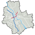
File:Warszawa - Linie metra.svg

Original file (SVG file, nominally 1,064 × 1,064 pixels, file size: 74 KB)
Captions
Captions
Summary edit
| DescriptionWarszawa - Linie metra.svg |
Polski: Mapa Warszawy z zaznaczonymi liniami metra. Stan na 16 września 2019.
Mapa jest wykorzystywana w szablonie Mapa dane Warszawa jako wariant metro, z którego korzysta Stacja metra infobox. This file was derived from: Warszawa outline with districts v4.svg |
| Date | |
| Source | Own work |
| Author | Jakub Murat |
Licensing edit
- You are free:
- to share – to copy, distribute and transmit the work
- to remix – to adapt the work
- Under the following conditions:
- attribution – You must give appropriate credit, provide a link to the license, and indicate if changes were made. You may do so in any reasonable manner, but not in any way that suggests the licensor endorses you or your use.
- share alike – If you remix, transform, or build upon the material, you must distribute your contributions under the same or compatible license as the original.
File history
Click on a date/time to view the file as it appeared at that time.
| Date/Time | Thumbnail | Dimensions | User | Comment | |
|---|---|---|---|---|---|
| current | 08:28, 30 September 2022 |  | 1,064 × 1,064 (74 KB) | Szczureq (talk | contribs) | odcinek na Bródno |
| 21:14, 1 July 2022 |  | 1,064 × 1,064 (75 KB) | Szczureq (talk | contribs) | odcinek na Bemowo | |
| 09:09, 4 April 2020 |  | 1,064 × 1,064 (76 KB) | Szczureq (talk | contribs) | odcinek wolski otwarty | |
| 10:35, 20 September 2019 |  | 1,064 × 1,064 (76 KB) | Szczureq (talk | contribs) | Poprawiony przebieg, by lepiej pasował do rzeczywistego położenia stacji M2. Odcinki w budowie i planowane są zapisane w pliku jako przezroczyste. | |
| 12:18, 16 September 2019 |  | 1,064 × 1,064 (66 KB) | Szczureq (talk | contribs) | korekta | |
| 12:10, 16 September 2019 |  | 1,064 × 1,064 (67 KB) | Szczureq (talk | contribs) | linia M2 wydłużona | |
| 17:26, 19 November 2015 |  | 1,064 × 1,064 (65 KB) | Muri 91 (talk | contribs) | Planowane stacje linii II i III nie są encyklopedyczne, dlatego nie będzie o nich artykułów i nie będą wskazywane na tej mapie, więc odcinki planowane są na razie zbędne. | |
| 15:56, 18 November 2015 |  | 1,064 × 1,064 (74 KB) | Muri 91 (talk | contribs) | Poprawione przebiegi, nieprzezroczyste odcinki planowane. | |
| 19:43, 13 March 2015 |  | 1,064 × 1,064 (72 KB) | Muri 91 (talk | contribs) | Obraz kwadratowy, grubsze linie linii metra, linia M1 nad linią M2, planowane odcinki linii M2, inna barwa wód. | |
| 19:32, 8 March 2015 |  | 1,065 × 1,063 (67 KB) | Muri 91 (talk | contribs) | User created page with UploadWizard |
You cannot overwrite this file.
File usage on Commons
The following 14 pages use this file:
- User:Chumwa/OgreBot/Potential transport maps/2019 September 11-20
- User:Chumwa/OgreBot/Public transport information/2015 November 11-20
- User:Chumwa/OgreBot/Public transport information/2019 September 11-20
- User:Chumwa/OgreBot/Public transport information/2020 April 1-10
- User:Chumwa/OgreBot/Public transport information/2022 July 1-10
- User:Chumwa/OgreBot/Public transport information/2022 September 21-30
- User:Chumwa/OgreBot/Transport Maps/2015 November 11-20
- User:Chumwa/OgreBot/Transport Maps/2019 September 11-20
- User:Chumwa/OgreBot/Transport Maps/2020 April 1-10
- User:Chumwa/OgreBot/Transport Maps/2022 July 1-10
- User:Chumwa/OgreBot/Transport Maps/2022 September 21-30
- User:Chumwa/OgreBot/Travel and communication maps/2019 September 11-20
- User:Cybularny/Warsaw/2019 September 16-30
- User:Cybularny/Warsaw/2020 April 1-15
File usage on other wikis
The following other wikis use this file:
- Usage on en.wikipedia.org
- Usage on hu.wikipedia.org
- Rondo Daszyńskiego metróállomás
- Rondo ONZ metróállomás
- Świętokrzyska metróállomás
- Nowy Świat-Uniwersytet metróállomás
- Centrum Nauki Kopernik metróállomás
- Stadion Narodowy metróállomás
- Dworzec Wileński metróállomás
- Młociny metróállomás
- Wawrzyszew metróállomás
- Stare Bielany metróállomás
- Słodowiec metróállomás
- Marymont metróállomás
- Plac Wilsona metróállomás
- Dworzec Gdański metróállomás
- Ratusz Arsenał metróállomás
- Centrum metróállomás
- Politechnika metróállomás
- Pole Mokotowskie metróállomás
- Racławicka metróállomás
- Wierzbno metróállomás
- Wilanowska metróállomás
- Służew metróállomás
- Ursynów metróállomás
- Stokłosy metróállomás
- Imielin metróállomás
- Natolin metróállomás
- Kabaty metróállomás
- Sablon:Pozíciós térkép Varsó/metró
- Usage on pl.wikipedia.org
- Centrum (stacja metra)
- Świętokrzyska (stacja metra)
- Plac Wilsona (stacja metra)
- Racławicka (stacja metra)
- Wierzbno (stacja metra)
- Politechnika (stacja metra)
- Pole Mokotowskie (stacja metra)
- Wilanowska (stacja metra)
- Służew (stacja metra)
- Ursynów (stacja metra)
- Stokłosy (stacja metra)
- Imielin (stacja metra)
- Natolin (stacja metra)
- Kabaty (stacja metra)
- Dworzec Gdański (stacja metra)
- Marymont (stacja metra)
- Stacja Techniczno-Postojowa Kabaty
- Plac Konstytucji (stacja metra)
- Muranów (stacja metra)
- Słodowiec (stacja metra)
View more global usage of this file.
Metadata
This file contains additional information such as Exif metadata which may have been added by the digital camera, scanner, or software program used to create or digitize it. If the file has been modified from its original state, some details such as the timestamp may not fully reflect those of the original file. The timestamp is only as accurate as the clock in the camera, and it may be completely wrong.
| Width | 1064 |
|---|---|
| Height | 1064 |