File:Washington State Congressional Districts 1993 – 2002.png

Size of this preview: 800 × 468 pixels. Other resolutions: 320 × 187 pixels | 640 × 374 pixels | 1,280 × 748 pixels.
Original file (1,280 × 748 pixels, file size: 1.19 MB, MIME type: image/png)
Captions
Captions
Add a one-line explanation of what this file represents
Summary edit
| Description |
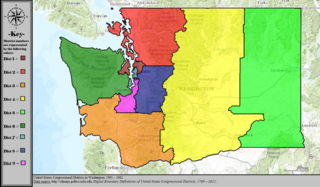
English: This map shows the map of the congressional districts from Washington state from the elections of 1993 to 2000 |
| Date | |
| Source | https://www.wikiwand.com/en/Washington%27s_congressional_districts |
| Author | No person took this photo |
Licensing edit
This file is licensed under the Creative Commons Attribution-Share Alike 4.0 International license.
- You are free:
- to share – to copy, distribute and transmit the work
- to remix – to adapt the work
- Under the following conditions:
- attribution – You must give appropriate credit, provide a link to the license, and indicate if changes were made. You may do so in any reasonable manner, but not in any way that suggests the licensor endorses you or your use.
- share alike – If you remix, transform, or build upon the material, you must distribute your contributions under the same or compatible license as the original.
File history
Click on a date/time to view the file as it appeared at that time.
| Date/Time | Thumbnail | Dimensions | User | Comment | |
|---|---|---|---|---|---|
| current | 16:57, 23 September 2021 | | 1,280 × 748 (1.19 MB) | Gordfather69 (talk | contribs) | Uploaded a work by No person took this photo from https://www.wikiwand.com/en/Washington%27s_congressional_districts with UploadWizard |
You cannot overwrite this file.
File usage on Commons
There are no pages that use this file.