File:We Dolom Puez-GeislerPano.jpg

Size of this preview: 800 × 334 pixels. Other resolutions: 320 × 134 pixels | 640 × 267 pixels | 1,024 × 428 pixels | 2,154 × 900 pixels.
Original file (2,154 × 900 pixels, file size: 596 KB, MIME type: image/jpeg)
Captions
Captions
Add a one-line explanation of what this file represents
Summary edit
| Description |
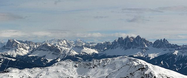
Deutsch: Fernansicht von Westen (im Mittelgrund): ganz links Peitlerkofel, halblinks davor Aferer Geisler, mittig: Medalges, rechts Geislergruppe und Seceda. Im Hintergrund halblinks östliche Dolmiten mit Kreuzkofel und Fanes
English: Puez-Geisler Nature Park, Panorama from West: View from Peitlerkofel (left Side) to Geislergroup /right Side) |
| Date | |
| Source | Own work |
| Author | Bbb |
Licensing edit
User: Bbb at wikivoyage shared, the copyright holder of this work, hereby publishes it under the following licenses:

|
Permission is granted to copy, distribute and/or modify this document under the terms of the GNU Free Documentation License, Version 1.2 or any later version published by the Free Software Foundation; with no Invariant Sections, no Front-Cover Texts, and no Back-Cover Texts. A copy of the license is included in the section entitled GNU Free Documentation License. |
This file is licensed under the Creative Commons Attribution-Share Alike 3.0 Unported, 2.5 Generic, 2.0 Generic and 1.0 Generic license.
Attribution: User: Bbb at wikivoyage shared
- You are free:
- to share – to copy, distribute and transmit the work
- to remix – to adapt the work
- Under the following conditions:
- attribution – You must give appropriate credit, provide a link to the license, and indicate if changes were made. You may do so in any reasonable manner, but not in any way that suggests the licensor endorses you or your use.
- share alike – If you remix, transform, or build upon the material, you must distribute your contributions under the same or compatible license as the original.
You may select the license of your choice.
Original upload log edit
| This file was imported from Wikivoyage Shared. |
The original description page was here. All following user names refer to wikivoyage-old/shared.
- 2011-11-08 21:10 Bbb archive copy at the Wayback Machine 2154×900 (610802 bytes) {{Information |Description={{de|Fernansicht von Westen (im Mittelgrund): ganz links Peitlerkofel, halblinks davor Aferer Geisler, mittig: Medalges, rechts Geeslergruppe und Seceda. Im Hintergrund östliche Dolmiten mit Kreuzkofel halblinks und Fanes}} {{en|Puez-Geisler Nature Park, Panoram from West: Peitlerkofel (left Side) to Geislergroup /right Side)}} |Author=[[User:Bbb|Bbb]] |Date=2009-02 |Source=self-made |Permission=See below |other_versions= }} [[Category:Puez-Geisler Nature Park]] [[Category:Images by Bbb]]
| Annotations | This image is annotated: View the annotations at Commons |
File history
Click on a date/time to view the file as it appeared at that time.
| Date/Time | Thumbnail | Dimensions | User | Comment | |
|---|---|---|---|---|---|
| current | 03:25, 13 November 2012 | | 2,154 × 900 (596 KB) | MGA73bot2 (talk | contribs) | {{BotMoveToCommons|shared.oldwikivoyage|year={{subst:CURRENTYEAR}}|month={{subst:CURRENTMONTHNAME}}|day={{subst:CURRENTDAY}}}} == {{int:filedesc}} == {{Information |description={{de|Fernansicht von Westen (im Mittelgrund): ganz links Peitlerkofel, halb... |
You cannot overwrite this file.
File usage on Commons
The following page uses this file:
File usage on other wikis
The following other wikis use this file:
- Usage on de.wikivoyage.org
- Usage on it.wikiversity.org