File:Welcome to Whitefish Island.JPG

Original file (3,264 × 2,448 pixels, file size: 3.67 MB, MIME type: image/jpeg)
Captions
Captions
Summary edit
| Description |
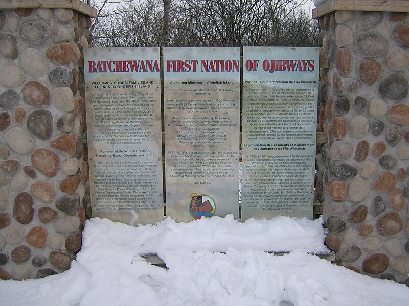
English: Batchewana First Nation of Ojibways
Welcome visitors, families and friends to Whitefish Island Whitefish Island Reserve is a territory of the Batchewana First Nation. Two treaties, the 1850 Robinson Huron and the 1859 Pennefather, specifically retained Whitefish Island and the small islands used as fishing stations for its benefit and use. The location of the 22 acre island was significant to the Anishnabe. It provided access to the rich fisheries at the St. Mary's rapids and as the travel route between Lakes Huron and Superior the area was a centre for trade and settlement. There was continuous occupation of the island until 1905 when the Anishnabe families living on the island were removed because of the land expropriations. Removal of the Whitefish Island Residents, Burial Grounds and Lands From 1900 to 1901, the Federal Government issued improper land expropriations on Whitefish Island to 3 railway companies. By 1906 Whitefish Island was expropriated for railroad use, all residents were removed from the Island, and the Indian Burial Ground grave sites were relocated to areas in Sault Ste. Marie. Interestingly, the Railway companies were subsidiaries of the Lake Superior Power Company. In 1913, the Federal Department of Public Works expropriated the land from the railroad companies. In 1980, Batchewana First Nation issued a land claim with the Federal Government seeking return of the island to reserve status. After a long battle, the island was returned to Batchewana First Nation in 1998. Anishinaabemowin: Adikameg Minising - Whitefish Island Aaniin! Kina weyaa, dinmakoonim bii Dikmej mnisenhing. Niish giidonan gchi minisneganan 1850 Robinson miinwaa 1859 Pennefather Niishtana shi niish aki Adikameg gii gwaabwaawan 1905 Anishinabec gii gojipcaan gi jigaaswok. Mewsha kina anishnaabeg gii bii yaawag, Anishnaabeg gii bimaawnjid wagimziwe gii Binjibaawag gii bii gii goonkewaad pii dikmegoog Aamiwag pii daagwagiing Miinwaa giimesh toon gewag miijim Shkweganin sii wagmisgan wiigwas Jiimaanan nigii chimendaamin kina Weyaa gii bii shaawaad miinwaa Giiminemaawaat. 1900-1901 Gichi goma gii commaan Anhishinaben Adikomeg Minising mii dash niwsi gichi iskode daabaan miikaan gii zhitiwass miinwaa Lake Superior Power Co. and the Federal Department of Public Works mii dash 1980 Batchewana ntam Anishinabe gii zhitoowaad ji doopniwaad adikomeg Minising niyaab. Adikiameg Minising niyaab gii miingaazok 1998. Baa Maa Pii.Français : Panneaux d'interprétation de l'île Whitefish
La réserve de l'île Whitefish est un territoire de la Première nation de Batchewana. En vertu de deux traités, le traité Robinson-Huron de 1850 et le traité Pennefather de 1859, la Première nation conserve pour son utilisation l'île Whitefish en particulier et les îlots environnants comme postes de pêche. L'emplacement de cette île de 22 acres est important pour les Anishnabes. Elle donne accès aux pêches abondantes des rapides de la St. Mary's et, comme elle constitue un passage nécessaire entre les lacs Huron et Supérieur, la région est propice au commerce et à l'établissement. L'île est habitée continuellement jusqu'en 1905, année où les familles anishnabes doivent quitter l'île en raison des expropriations. Expropriation des résidents et déplacement des cimetières de l'île Whitefish De 1900 à 1901, le gouvernement fédéral procède à des expropriations indues de terrains sur l'île Whitefish en faveur de trois compagnies ferroviaires. En 1906, l'île Whitefish est expropriée pour y construire le chemin de fer; les résidents doivent quitter l'île, et les cimetières indiens sont déplacés dans la région de Sault Ste. Marie. Il est intéressant de préciser que les compagnies ferroviaires étaient des filiales de la Lake Superior Power Company. En 1913, le ministère fédéral des Travaux publics exproprie les terrains des compagnies ferroviaires. En 1980, la Première nation de Batchewana présent une revendication territoriale au gouvernement fédéral afin que l'île retrouve sont statut de réserve. Après un long combat, l'île est rendue à la Première nation Batchewana en 1998. |
| Date | |
| Source | Own work |
| Author | Fungus Guy |
Licensing edit
- You are free:
- to share – to copy, distribute and transmit the work
- to remix – to adapt the work
- Under the following conditions:
- attribution – You must give appropriate credit, provide a link to the license, and indicate if changes were made. You may do so in any reasonable manner, but not in any way that suggests the licensor endorses you or your use.
- share alike – If you remix, transform, or build upon the material, you must distribute your contributions under the same or compatible license as the original.
File history
Click on a date/time to view the file as it appeared at that time.
| Date/Time | Thumbnail | Dimensions | User | Comment | |
|---|---|---|---|---|---|
| current | 00:49, 21 March 2013 | | 3,264 × 2,448 (3.67 MB) | Fungus Guy (talk | contribs) | User created page with UploadWizard |
You cannot overwrite this file.
File usage on Commons
The following page uses this file: